
Callaway topographic map
Click on the map to display elevation.
About this map
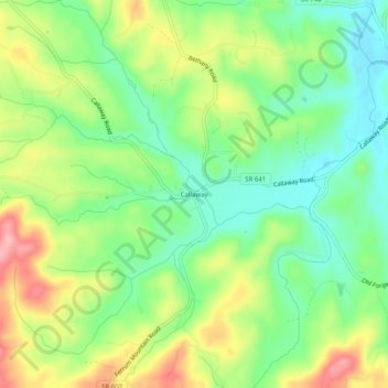
Name: Callaway topographic map, elevation, terrain.
Location: Callaway, Franklin County, Virginia, 24067, United States (36.99153 -80.06948 37.03153 -80.02948)
Average elevation: 398 m
Minimum elevation: 345 m
Maximum elevation: 477 m
Other topographic maps
Click on a map to view its topography, its elevation and its terrain.
Boones Mill
United States > Virginia > Franklin County
According to the United States Census Bureau, the town has a total area of 0.73 square miles (1.9 km2), all of it land. The town is in the valley of Maggodee Creek, a southeast-flowing tributary of the Blackwater River, part of the Roanoke River watershed. Murray Knob, elevation 2,286 feet (697 m), rises 2…
Average elevation: 390 m