
Ola topographic map
Interactive map
Click on the map to display elevation.
About this map
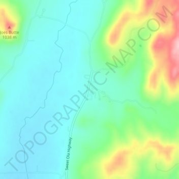
Name: Ola topographic map, elevation, terrain.
Location: Ola, Gem County, Idaho, United States (44.16796 -116.30294 44.18796 -116.28294)
Average elevation: 943 m
Minimum elevation: 897 m
Maximum elevation: 1,062 m
Other topographic maps
Click on a map to view its topography, its elevation and its terrain.
Emmett
United States > Idaho > Gem County
Emmett, Gem County, Idaho, United States
Average elevation: 738 m
Sweet
United States > Idaho > Gem County
Sweet, Gem County, Idaho, 83670, United States
Average elevation: 811 m