
Zarakes topographic map
Interactive map
Click on the map to display elevation.
About this map
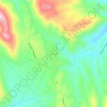
Name: Zarakes topographic map, elevation, terrain.
Average elevation: 154 m
Minimum elevation: 10 m
Maximum elevation: 411 m
Other topographic maps
Click on a map to view its topography, its elevation and its terrain.
Παλιούρια
Griechenland > Thessalien - Mittelgriechenland > Regionalbezirk Euböa
Παλιούρια, Δήμος Κύμης - Αλιβερίου, Regionalbezirk Euböa, Region Mittelgriechenland, Thessalien - Mittelgriechenland, Griechenland
Average elevation: 116 m
Karystos
Griechenland > Thessalien - Mittelgriechenland > Regionalbezirk Euböa
Karystos, Δήμος Καρύστου, Regionalbezirk Euböa, Region Mittelgriechenland, Thessalien - Mittelgriechenland, 340 01, Griechenland
Average elevation: 167 m