
Karystos topographic map
Interactive map
Click on the map to display elevation.
About this map
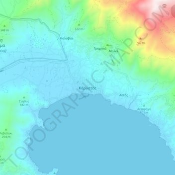
Name: Karystos topographic map, elevation, terrain.
Average elevation: 167 m
Minimum elevation: 0 m
Maximum elevation: 1,202 m
In der Nähe von Karystos wurden bei 24,6° östliche Länge und 38,0° nördliche Breite anlässlich der ringförmig-totalen Sonnenfinsternis am 20. Mai 1966 12 Höhenforschungsraketen gestartet, und zwar fünf Raketen vom Typ "Sparrow Arcas", fünf vom Typ "Arcas" und zwei vom Type Centaure. Im Vorfeld dieser Aktion wurden am 15. Mai 1966 eine Rakete vom Typ Sparrow Arcas, eine Rakete vom Typ Centaure und eine Rakete vom Typ Arcas gestartet. Eine weitere Rakete des Typs Arcas wurde am 21. Mai 1966 gestartet.
Other topographic maps
Click on a map to view its topography, its elevation and its terrain.
Zarakes
Griechenland > Thessalien - Mittelgriechenland > Regionalbezirk Euböa
Zarakes, Δήμος Κύμης - Αλιβερίου, Regionalbezirk Euböa, Region Mittelgriechenland, Thessalien - Mittelgriechenland, 340 17, Griechenland
Average elevation: 154 m
Παλιούρια
Griechenland > Thessalien - Mittelgriechenland > Regionalbezirk Euböa
Παλιούρια, Δήμος Κύμης - Αλιβερίου, Regionalbezirk Euböa, Region Mittelgriechenland, Thessalien - Mittelgriechenland, Griechenland
Average elevation: 116 m