
Thank you for supporting this site ❤️
Make a donation
Make a donation
Franklin topographic map
Click on the map to display elevation.
Thank you for supporting this site ❤️
Make a donation
Make a donation
About this map
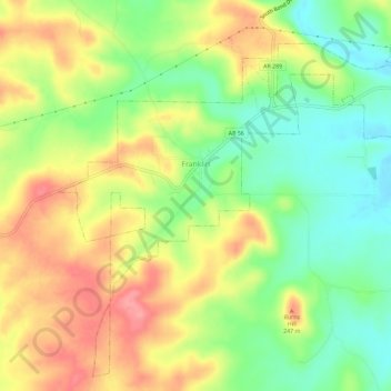
Name: Franklin topographic map, elevation, terrain.
Location: Franklin, Izard County, Arkansas, United States (36.14497 -91.79633 36.18814 -91.73866)
Average elevation: 203 m
Minimum elevation: 157 m
Maximum elevation: 253 m
Thank you for supporting this site ❤️
Make a donation
Make a donation
Other topographic maps
Click on a map to view its topography, its elevation and its terrain.
Thank you for supporting this site ❤️
Make a donation
Make a donation
Thank you for supporting this site ❤️
Make a donation
Make a donation
Thank you for supporting this site ❤️
Make a donation
Make a donation