
Dojkinci topographic map
Interactive map
Click on the map to display elevation.
About this map
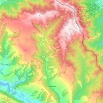
Name: Dojkinci topographic map, elevation, terrain.
Average elevation: 1,250 m
Minimum elevation: 597 m
Maximum elevation: 1,968 m
Other topographic maps
Click on a map to view its topography, its elevation and its terrain.
Stara planina
Serbia > Central Serbia > Pirot Administrative District > Topli Do
The park's herpetofauna includes 15 reptile and nine amphibian species. It hosts vital populations of common European adder (Vipera berus), European toad, grass snake (Natrix natrix), legless lizard, tessellated water snake, viviparous lizard and the common frog. Due to the park's high altitude, the…
Average elevation: 1,806 m
Vava
Serbia > Central Serbia > Pirot Administrative District > Babusnica Municipality > Vava
Average elevation: 726 m