
Make a donation
Claysville topographic map
Click on the map to display elevation.
Make a donation
About this map
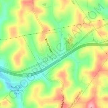
Name: Claysville topographic map, elevation, terrain.
Location: Claysville, Washington County, Pennsylvania, United States (40.11318 -80.42064 40.12443 -80.40769)
Average elevation: 379 m
Minimum elevation: 319 m
Maximum elevation: 444 m
Make a donation
Other topographic maps
Click on a map to view its topography, its elevation and its terrain.
Make a donation
Stogletown
United States > Pennsylvania > Washington County > Monongahela > Monongahela
Average elevation: 291 m
Hill Church
United States > Pennsylvania > Washington County > North Strabane Township
Average elevation: 346 m
Enterprise
United States > Pennsylvania > Washington County > South Strabane Township
Average elevation: 334 m
Hazel Kirk
United States > Pennsylvania > Washington County > Carroll Township
Average elevation: 311 m
Make a donation
Vestaburg
United States > Pennsylvania > Washington County > East Bethlehem Township
Average elevation: 308 m
Make a donation
Acheson
United States > Pennsylvania > Washington County > Independence Township
Average elevation: 325 m
Bower Hill
United States > Pennsylvania > Washington County > Peters Township
Average elevation: 348 m
Strabane
United States > Pennsylvania > Washington County > North Strabane Township
Average elevation: 329 m
Make a donation
Lake Jo-Ann
United States > Pennsylvania > Washington County > Peters Township
Average elevation: 343 m
Hickory
United States > Pennsylvania > Washington County > Mount Pleasant Township
Average elevation: 371 m
Fredericktown
United States > Pennsylvania > Washington County > East Bethlehem Township
Average elevation: 306 m
Make a donation
Eighty Four
United States > Pennsylvania > Washington County > North Strabane Township
Average elevation: 345 m
Prosperity
United States > Pennsylvania > Washington County > Morris Township > Prosperity
Average elevation: 352 m
Buffalo
United States > Pennsylvania > Washington County > Hopewell Township > Buffalo
Average elevation: 370 m
Bulger
United States > Pennsylvania > Washington County > Smith Township > Bulger
Average elevation: 354 m
Make a donation
Clover Hill
United States > Pennsylvania > Washington County > West Pike Run Township > Clover Hill
Average elevation: 347 m
Murry Hill
United States > Pennsylvania > Washington County > North Strabane Township
Average elevation: 319 m