Geolocate

South Dakota topographic map

Interactive map

Click on the map to display elevation.

South Dakota

Black Elk Peak, formerly named Harney Peak, with an elevation of 7,242 ft (2,207 m), is the state's highest point, while the shoreline of Big Stone Lake is the lowest, with an elevation of 966 ft (294 m). South Dakota is bordered to the north by North Dakota; to the south by Nebraska; to the east by Iowa and Minnesota; and to the west by Wyoming and Montana. The geographical center of the U.S. is 17 miles (27 km) west of Castle Rock in Butte County. The North American continental pole of inaccessibility is between Allen and Kyle, 1,024 mi (1,648 km) from the nearest coastline.

Wikipedia (CC-BY-SA 3.0)

About this map

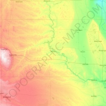
Name: South Dakota topographic map, elevation, terrain.

Location: South Dakota, United States (42.47989 -104.05776 45.94534 -96.43634)

Average elevation: 717 m

Minimum elevation: 274 m

Maximum elevation: 2,166 m

Other topographic maps

Click on a map to view its topography, its elevation and its terrain.

San Antonio

United States > Texas > Bexar County > San Antonio

Average elevation: 218 m

Appalachian Mountains

United States > North Carolina > Yancey County

The Appalachian Mountains (French: Appalaches), often called the Appalachians, are a system of mountains in eastern to northeastern North America. The Appalachians first formed roughly 480 million years ago during the Ordovician Period. They once reached elevations similar to those of the Alps and the Rocky…

Average elevation: 1,463 m

Estes Park

United States > Colorado > Larimer County

Estes Park sits at an elevation of 7,522 feet (2,293 m) on the front range of the Rocky Mountains at the eastern entrance of the Rocky Mountain National Park. Its north, south and east extremities border the Roosevelt National Forest. Lumpy Ridge lies immediately north of Estes Park.

Average elevation: 2,543 m

Virginia Beach

United States > Virginia > Virginia Beach

According to the United States Census Bureau, the city has a total area of 497 square miles (1,290 km2), of which 249 square miles (640 km2) is land and 248 square miles (640 km2) (49.9%) is water. It is the largest city in Virginia by total area and third-largest city land area. The average elevation is 12…

Average elevation: 2 m

San Francisco Bay Area

United States > California > San Francisco

The San Francisco Bay Area is characterized by a diverse and dynamic topography shaped by geological processes over millions of years. This region features a combination of coastal plains, steep hills, and rugged mountains, all influenced by the tectonic activity associated with the nearby San Andreas Fault…

Average elevation: 113 m

Florida Keys

United States > Florida > Monroe County

Tropical cyclones present special dangers and challenges to the entire Keys. Because no area of the islands is more than 20 feet (6.1 m) above sea level (and many are only a few feet elevation), and water surrounds the islands, nearly every neighborhood is subject to flooding as well as hurricane winds. In…

Average elevation: 0 m

San Diego

United States > California > San Diego County > San Diego

The climate in San Diego, like most of Southern California, often varies significantly over short geographical distances, resulting in microclimates. In San Diego, this is mostly because of the city's topography (the Bay, and the numerous hills, mountains, and canyons). Frequently, particularly during the "May…

Average elevation: 57 m

Biloxi

United States > Mississippi > Harrison County > Biloxi

Average elevation: 1 m

Baltimore

United States > Maryland > Baltimore

Baltimore is in north-central Maryland on the Patapsco River close to where it empties into the Chesapeake Bay. The city is also located on the fall line between the Piedmont Plateau and the Atlantic coastal plain, which divides Baltimore into "lower city" and "upper city". The city's elevation ranges from sea…

Average elevation: 65 m

Vail

United States > Colorado > Eagle County

Vail's average elevation is 8,150 feet (2484 m) above sea level. The town has a total area of 4.5 square miles (12 km2), with no lakes (there is, however, at least one pond). Gore Creek flows from east to west through the center of town.

Average elevation: 2,953 m

West Oneida

United States > Tennessee > Scott County > Oneida

Average elevation: 453 m

Appalachian Mountains

United States > North Carolina > Yancey County

The Appalachian Mountains (French: Appalaches), often called the Appalachians, are a system of mountains in eastern to northeastern North America. The Appalachians first formed roughly 480 million years ago during the Ordovician Period. They once reached elevations similar to those of the Alps and the Rocky…

Average elevation: 1,463 m

Idaville

United States > Indiana > White County

Average elevation: 213 m

Mauna Loa

United States > Hawaii > Hawaiʻi County

Mauna Loa is the largest subaerial and second largest overall volcano in the world (behind Tamu Massif), covering a land area of 5,271 km2 (2,035 sq mi) and spans a maximum width of 120 km (75 mi). Consisting of approximately 65,000 to 80,000 km3 (15,600 to 19,200 cu mi) of solid rock, it makes up more than…

Average elevation: 4,037 m

Beverly

United States > Massachusetts > Essex County > Beverly

Average elevation: 17 m

Whitney Portal

United States > California > Inyo County

Average elevation: 2,676 m

Mount Washington

United States > New Hampshire > Coos County

Mount Washington, also known as Agiocochook, is an ultra-prominent mountain in the state of New Hampshire. It is the highest peak in the Northeastern United States at 6,288.2 ft (1,916.6 m) and the most topographically prominent mountain east of the Mississippi River.

Average elevation: 1,568 m

Puget Sound

United States > Washington > Edmonds

Average elevation: 0 m

Norfolk

United States > Virginia > Norfolk

Average elevation: 4 m

Emory Peak

United States > Texas > Brewster County

The peak can be reached by a moderate hike on a well-marked path across steep rocky terrain with an elevation gain of approximately 2,500 feet (760 m). The Emory Peak Trail is about 1.5 miles (2.4 km) long. The trail is reached by climbing the Pinnacles Trail 3.5 miles (5.6 km) from the Chisos Basin trailhead.…

Average elevation: 2,061 m

Hanover

United States > New Mexico > Grant County

Average elevation: 1,989 m

Hoover Dam

United States > Arizona > Mohave County

The amount of electricity generated by Hoover Dam has been decreasing along with the falling water level in Lake Mead due to the prolonged drought since year 2000 and high demand for the Colorado River's water. By 2014 its generating capacity was downrated by 23% to 1592 MW and was providing power only during…

Average elevation: 429 m

Crested Butte

United States > Colorado > Gunnison County

Crested Butte is located in north-central Gunnison County on the west side of the valley of the Slate River, along Coal Creek. Colorado State Highway 135 runs south from Crested Butte 27 miles (43 km) to Gunnison, the county seat. According to the United States Census Bureau, the town of Crested Butte has a…

Average elevation: 2,798 m

Babylon

United States > Illinois > Fulton County

Average elevation: 178 m

Trinity

United States > North Carolina > Union County

Average elevation: 190 m

Beulah

United States > North Carolina > Polk County

Average elevation: 287 m

Black Hills

United States > South Dakota > Pennington County

The Black Hills is an isolated mountain range rising from the Great Plains of North America in western South Dakota and extending into Wyoming, United States. Black Elk Peak, which rises to 7,242 feet (2,207 m), is the range's highest summit. The name of the range in Lakota is Pahá Sápa. It encompasses the…

Average elevation: 1,894 m

Central Park

United States > New York > New York County > New York

In June 1856, Fernando Wood appointed a "consulting board" of seven people, headed by author Washington Irving, to inspire public confidence in the proposed development. Wood hired military engineer Egbert Ludovicus Viele as the park's chief engineer, tasking him with a topographical survey of the site. The…

Average elevation: 26 m

Lexington

United States > Kentucky > Lexington

Average elevation: 285 m

Fresno

United States > California > Fresno County

Average elevation: 98 m

Parrish

United States > Florida > Manatee County

Parrish features a predominantly flat terrain with an average elevation of approximately 36 feet above sea level. The area's landscape is characterized by gently rolling hills and low-lying regions, making it typical of the Central Florida topography. Surrounding Parrish are numerous wetlands and drainage…

Average elevation: 12 m

Evergreen

United States > Colorado > Jefferson County

Evergreen sits at an elevation of 7,220 feet (2,200 m) in the Rocky Mountains, 19 miles west of Denver, Colorado. Its addresses are oriented according to the Street_system_of_Denver.

Average elevation: 2,309 m

Bogart Park

United States > Indiana > Vermillion County > Clinton

Average elevation: 150 m

Fountain Lakes

United States > Florida > Lee County

Average elevation: 5 m

Jasper

United States > Oregon > Lane County

Average elevation: 187 m

Bokeelia

United States > Florida > Lee County

Average elevation: 1 m

Amanda

United States > Florida > Hillsborough County > Ruskin

Average elevation: 5 m

Dunlap

United States > California > Fresno County

Average elevation: 667 m

Anna Maria island

United States > Florida > Manatee County

Anna Maria Island features a flat, sandy topography typical of a barrier island on the Gulf Coast. With an average elevation of around 15 feet above sea level, the terrain includes broad beaches, low dunes, and narrow stretches of sandy soil, making it highly vulnerable to storm surges and tidal flooding. The…

Average elevation: 2 m

Scottsdale

United States > Arizona > Maricopa County > Scottsdale

The city is in the Salt River Valley, or the "Valley of the Sun," in the northern reaches of the Sonoran Desert. Scottsdale, 31 mi (50 km) long and 11.4 mi (18.3 km) wide at its widest point, shares boundaries with many other municipalities and entities. On the west, Scottsdale is bordered by Phoenix, Paradise…

Average elevation: 414 m

Highlands

United States > North Carolina > Macon County > Highlands

Highlands was founded in 1875 after its two founders, Samuel Truman Kelsey and Clinton Carter Hutchinson, drew lines from Chicago to Savannah and from New Orleans to New York City. They felt that the place where these lines met would eventually become a great trading center and commercial crossroads. Highlands…

Average elevation: 1,090 m

Mount Rushmore

United States > South Dakota > Pennington County

Mount Rushmore National Memorial is centered on a colossal sculpture carved into the granite face of Mount Rushmore (Lakota: Tȟuŋkášila Šákpe, or Six Grandfathers) in the Black Hills near Keystone, South Dakota. Sculptor Gutzon Borglum created the sculpture's design and oversaw the project's execution…

Average elevation: 1,562 m

Homosassa

United States > Florida > Citrus County > Homosassa

Average elevation: 3 m

Steamboat Springs

United States > Colorado > Routt County

Average elevation: 2,228 m

Windemere

United States > Alaska > Anchorage

Average elevation: 33 m

Lake Windemere

United States > Indiana > Hamilton County > Carmel

Average elevation: 273 m

Cookville

United States > Texas > Titus County

Average elevation: 128 m

Banded Peak

United States > Colorado > Archuleta County

Average elevation: 3,557 m

Gateway

United States > Colorado > Mesa County

Average elevation: 1,469 m

Mahon

United States > Indiana > Huntington County

Average elevation: 238 m

Doughton

United States > North Carolina > Wilkes County

Average elevation: 499 m

Coast Range

United States > Oregon > Benton County

Average elevation: 824 m

Mount Washington

United States > New Hampshire > Coos County

Mount Washington, in New Hampshire, is the highest peak in the Northeastern United States at 6,288.2 ft (1,916.6 m) and the most topographically prominent mountain east of the Mississippi River.

Average elevation: 1,568 m

Pikes Peak

United States > Colorado > El Paso County

Soils on Pikes Peak above the timberline (approximately 12,000 ft or 3,700 m) are classified as Cirque land. Forests at lower altitudes mostly lie over the brown stony, sandy, loams of the Catamount loam or Ivywild loam series.

Average elevation: 3,902 m

Cypress

United States > Texas > Harris County

Average elevation: 46 m

Fairplay

United States > Colorado > Park County

The historic Town of Fairplay is the Statutory Town that is the county seat and the most populous municipality of Park County, Colorado, United States. The town population was 724 at the 2020 United States Census. Fairplay is located in South Park at an elevation of 9,953 feet (3,034 m). The town is the…

Average elevation: 3,045 m

Indianapolis

United States > Indiana > Indianapolis

Indianapolis is within the Tipton Till Plain, a flat to gently sloping terrain underlain by glacial deposits known as till. The lowest point in the city is about 650 feet (198 m) above mean sea level, with the highest natural elevation at about 900 feet (274 m) above sea level. Few hills or short ridges, known…

Average elevation: 241 m

Ponte Vedra Beach

United States > Florida > Saint Johns County > Ponte Vedra Beach

Ponte Vedra Beach is characterized by its gently rolling terrain that is primarily flat and lies only about 15 feet above sea level. The landscape is predominantly shaped by coastal dunes and the proximity to the Atlantic Ocean, resulting in sandy beaches interspersed with vegetation typical of barrier island…

Average elevation: 3 m

Winfield

United States > Colorado > Chaffee County

Average elevation: 3,445 m

Leburn

United States > Kentucky > Knott County

Average elevation: 414 m

Ogden Valley

United States > Utah > Weber County

Average elevation: 1,883 m

Mercer Dam

United States > Maine > Franklin County > Chesterville

Average elevation: 122 m

Chestatee North

United States > Georgia > Hall County

Average elevation: 353 m

Campton Township

United States > Illinois > Kane County

Average elevation: 267 m

Johnston Dam

United States > Colorado > Jefferson County

Average elevation: 1,689 m