
Wyoming topographic map
Interactive map
Click on the map to display elevation.
About this map
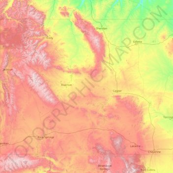
Name: Wyoming topographic map, elevation, terrain.
Location: Wyoming, United States (40.99482 -111.05527 45.00583 -104.05239)
Average elevation: 1,938 m
Minimum elevation: 916 m
Maximum elevation: 4,047 m
Wyoming's western half is covered mostly by the ranges and rangelands of the Rocky Mountains, while the eastern half of the state is high-elevation prairie called the High Plains. It is drier and windier than the rest of the country, being split between semi-arid and continental climates with greater temperature extremes. Almost half of the land in Wyoming is owned by the federal government, generally protected for public uses. The state ranks 6th by area and fifth by proportion of a state's land owned by the federal government. Federal lands include two national parks (Grand Teton and Yellowstone), two national recreation areas, two national monuments, several national forests, historic sites, fish hatcheries, and wildlife refuges.
Other topographic maps
Click on a map to view its topography, its elevation and its terrain.
Houston
United States > Texas > Harris County
Houston, Harris County, Texas, United States
Average elevation: 25 m
Boulder
United States > Colorado > Boulder County
Boulder, Boulder County, Colorado, United States
Average elevation: 1,785 m
Montgomery County
Montgomery County, Texas, United States
Average elevation: 69 m
Los Angeles
Los Angeles, Los Angeles County, California, United States
Average elevation: 241 m
The Woodlands
United States > Texas > Montgomery County
The Woodlands, Montgomery County, Texas, United States
Average elevation: 47 m
Spokane
United States > Washington > Spokane County
Spokane, Spokane County, Washington, United States
Average elevation: 655 m
Lancaster County
Lancaster County, Pennsylvania, United States
Average elevation: 158 m
Hudson River
Hudson River, New Jersey, 12834:12871, United States
Average elevation: 297 m
Fort Worth
United States > Texas > Tarrant County
Fort Worth, Tarrant County, Texas, United States
Average elevation: 212 m
Brooklyn
United States > New York > New York
Brooklyn, Kings County, New York, United States
Average elevation: 9 m
New Orleans
United States > Louisiana > Orleans Parish
New Orleans, Orleans Parish, Louisiana, United States
Average elevation: 1 m
Sequoia National Park
United States > California > Tulare County
Sequoia National Park, Tulare County, California, United States
Average elevation: 2,515 m
Tomball
United States > Texas > Harris County
Tomball, Harris County, Texas, 77375, United States
Average elevation: 52 m
Queens County
United States > New York > New York
Queens County, New York, United States
Average elevation: 11 m
Black Hills
United States > South Dakota > Pennington County
Black Hills, Pennington County, South Dakota, United States
Average elevation: 1,894 m