
Thank you for supporting this site ❤️
Make a donation
Make a donation
Mosquero topographic map
Click on the map to display elevation.
Thank you for supporting this site ❤️
Make a donation
Make a donation
About this map
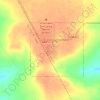
Name: Mosquero topographic map, elevation, terrain.
Location: Mosquero, Harding County, New Mexico, 87733, United States (35.76687 -103.96341 35.78157 -103.94550)
Average elevation: 1,694 m
Minimum elevation: 1,665 m
Maximum elevation: 1,706 m
Thank you for supporting this site ❤️
Make a donation
Make a donation
Other topographic maps
Click on a map to view its topography, its elevation and its terrain.