
Philadelphia topographic map
Click on the map to display elevation.
About this map
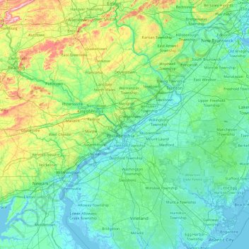
Name: Philadelphia topographic map, elevation, terrain.
Location: Philadelphia, Pennsylvania, 19140, United States (39.31145 -75.83265 40.71145 -74.43265)
Average elevation: 68 m
Minimum elevation: -4 m
Maximum elevation: 496 m
Other topographic maps
Click on a map to view its topography, its elevation and its terrain.
Pittsburgh
United States > Pennsylvania > Allegheny County
Pittsburgh, located in Allegheny County, Pennsylvania, is characterized by its distinct and varied topography, shaped by the confluence of the Allegheny, Monongahela, and Ohio rivers. The city itself is situated at an average elevation of approximately 764 feet (233 meters) above sea level, with the terrain…
Average elevation: 303 m
Philadelphia
United States > Pennsylvania > Philadelphia County
Philadelphia, located at the confluence of the Delaware and Schuylkill Rivers, features a diverse topography characterized by its gentle slopes and valleys. The city lies on the Atlantic Seaboard Fall Line, transitioning from the flat Coastal Plain to the more rugged Piedmont region. This unique geographical…
Average elevation: 44 m
Pottstown
United States > Pennsylvania > Montgomery County
Pottstown lacks an official weather station as administered from the regional National Weather Service office in Mount Holly, New Jersey. Temperatures average a little higher than the closest official weather station serving Reading from Bern Township, Berks County due to the difference in latitude and…
Average elevation: 69 m
Chester County
Chester County lies within southeastern Pennsylvania’s Piedmont landscape, where the terrain is shaped by a sequence of rolling uplands, elongated ridges, and stream-cut valleys rather than by broad plains or high mountains. Its relief is especially varied across the northern and western parts of the county,…
Average elevation: 124 m
Bethel Park
United States > Pennsylvania > Allegheny County
According to the U.S. Census Bureau, the borough had a total area of 11.7 square miles (30 km2), all of it land. Its average elevation is 1,197 feet (365 m) above sea level. Bethel Park lies at the margin between the Pittsburgh Low Plateau and Waynesburg Hills Sections of the Allegheny Plateau physiographic…
Average elevation: 347 m
Scranton
United States > Pennsylvania > Lackawanna County
Center City is about 750 feet (229 m) above sea level, although the hilly city's inhabited portions range about from 650 to 1,400 feet (200 to 430 m). The city is flanked by mountains to the east and west whose elevations range from 1,900 to 2,100 feet (580 to 640 m).
Average elevation: 360 m
Erie County
Most of the county has a warm-summer humid continental climate (Dfb), except at lower elevations near enough to the lake, where a hot-summer humid continental climate (Dfa) exists. Average monthly temperatures in downtown Erie range from 26.4 °F in January to 70.8 °F in July, while in Corry they range from…
Average elevation: 248 m
Allegheny County
Allegheny has a humid continental climate which is hot-summer, (Dfa) except in higher elevations, where it is warm-summer (Dfb).
Average elevation: 325 m
Somerset County
Somerset County along with Garrett County is one of the snowiest inhabited locations in the United States, with the highest elevations of the county averaging 150+ inches of snow each winter. The county's elevation and general proximity to both the Great Lakes and the Atlantic Ocean causes snow from both…
Average elevation: 632 m
Fort Indiantown Gap
United States > Pennsylvania > Lebanon County > Union Township
Average elevation: 234 m
State College
United States > Pennsylvania > Centre County
State College is situated at an elevation of approximately 1,200 feet (370 m) above sea level. According to the U.S. Census Bureau, the borough has a total area of 4.5 square miles (12 km2), all of it land. It is surrounded by large tracts of farmland, and an expanse of Appalachian Mountain ranges and forests.…
Average elevation: 351 m
Roxborough
United States > Pennsylvania > Philadelphia County > Philadelphia
Since the 1950s, most of Philadelphia's major television and FM radio stations have located their transmission towers in Roxborough because of its hilly terrain and high elevation. The tallest of these towers, the American Tower, stands approximately 1,250 feet (381m) tall. Public television station "MiND",…
Average elevation: 63 m
Jim Thorpe
United States > Pennsylvania > Carbon County
In the deeps of the geologic timescale the two shorelines of the Lehigh River occupied by the 19th-century towns of Mauch Chunk and East Mauch Chunk were situated on the bottom of an ancient river-fed tarn, a mountain lake which filled the valley on the west bank and covered the relative flatlands on the east…
Average elevation: 327 m
Nazareth
United States > Pennsylvania > Northampton County
Nazareth's climate is similar to the rest of the Lehigh Valley with four distinct seasons, humid summers, cold winters, and very short and mild springs and falls. This climate is hot-summer humid continental (Dfa) and average monthly temperatures range from 28.1 °F (−2.2 °C) in January to 73.4 °F (23.0…
Average elevation: 149 m
Monroe County
According to the Trewartha climate classification system, the higher elevation Pocono Plateau Region of Monroe County has a Temperate Continental climate (Dc) with warm summers (b), cold winters (o) and year-around precipitation (Dcbo). Dcbo climates are characterized by at least one month having an average…
Average elevation: 361 m
Hummelstown
United States > Pennsylvania > Dauphin County
Hummelstown is located in southern Dauphin County at 40°15′55″N 076°42′30″W / 40.26528°N 76.70833°W / 40.26528; -76.70833 (40.265168, −76.710995) at an elevation of 397 feet (121 m) above sea level. According to the United States Census Bureau, the borough has a total area of 1.3 square…
Average elevation: 117 m
Saint Marys
United States > Pennsylvania > Elk County
According to the United States Census Bureau, the city has a total area of 99.5 square miles (258 km2), of which 99.3 sq mi (257 km2) is land and 0.2 sq mi (0.52 km2) (0.16%) is water. Most of that area is unurbanized, and the large size is due to the city's 1992 merger with surrounding Benzinger Township. The…
Average elevation: 569 m
Treasure Lake
United States > Pennsylvania > Clearfield County > Sandy Township
Average elevation: 511 m
Hydetown
United States > Pennsylvania > Crawford County
Hydetown Borough is located just south of the southern terminal moraine for glaciation in northwestern Pennsylvania. The borough is drained by Oil Creek, a southward-flowing tributary of the Allegheny River, which runs through the northwestern and southwestern sides of the borough and Thompson Creek, which…
Average elevation: 412 m
Bridgeville
United States > Pennsylvania > Allegheny County
Even more significant to the development of Bridgeville was the advent of commercial coal mining. The Pittsburgh Coal Seam was perhaps the most valuable mineral resource in North America in the late 1800s. Ranging from forty inches to six feet thick it was located at an elevation that produced outcroppings on…
Average elevation: 275 m
Luzerne County
The Wyoming Valley, also referred to as the Anthracite Valley Section of Pennsylvania, runs directly through Luzerne County. It extends from the northeastern border (with Lackawanna County) to the western border (with Columbia County). The valley is flat (at the Susquehanna Basin) and rises from 512 feet (156…
Average elevation: 402 m
Allegheny County
Allegheny has a humid continental climate which is hot-summer, (Dfa) except in higher elevations, where it is warm-summer (Dfb).
Average elevation: 325 m
Lehigh County
Lehigh County borders two Appalachian mountain ridges. To the north, the county borders Blue Mountain, which has an altitude of 1,300 to 1,604 feet (396 to 489 m). To the south, it is bordered by South Mountain, which has an altitude of 700 to 1,100 feet (210 to 340 m) and cuts through the southern portions of…
Average elevation: 186 m
Bucks County
According to the Trewartha climate classification system, the Piedmont (United States) section of Bucks County, which is located roughly northwest of U.S. Route 1, has a Temperate Continental Climate with hot and slightly humid summers, cold winters and year-around precipitation (Dcao). Dcao climates are…
Average elevation: 98 m
Centre County
Centre County has a humid continental climate (Dfb/Dfa at lower elevations).
Average elevation: 427 m
Sullivan County
Elevation ranges from 2593 ft at North Mountain in Davidson Township to 779 ft on Loyalsock Creek at the Lycoming County line. The county is served by Pennsylvania Route 42, Pennsylvania Route 87, Pennsylvania Route 154, Pennsylvania Route 487, and U.S. Route 220. The major rivers in the county are Loyalsock…
Average elevation: 491 m
Pike County
The terrain rises rapidly from the river valley in the east to the rolling foothills of the Poconos in the west. The highest point is one of two unnamed hills in Greene Township that top out at approximately 2,110 feet (643 m) above sea level. The lowest elevation is approximately 340 feet (103.6 m), at the…
Average elevation: 361 m