
Philadelphia topographic map
Click on the map to display elevation.
About this map
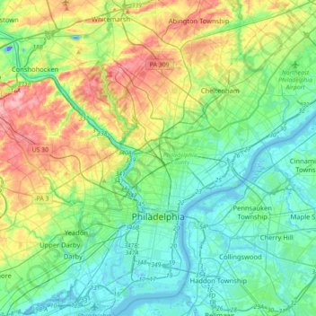
Name: Philadelphia topographic map, elevation, terrain.
Average elevation: 44 m
Minimum elevation: -40 m
Maximum elevation: 155 m
Other topographic maps
Click on a map to view its topography, its elevation and its terrain.
Pastorius Park
United States > Pennsylvania > Philadelphia County > Philadelphia
Average elevation: 108 m
Strawberry Mansion
United States > Pennsylvania > Philadelphia County > Philadelphia
Average elevation: 31 m
East Passyunk Community Recreation Center
United States > Pennsylvania > Philadelphia County > Philadelphia
Average elevation: 9 m
Bartram's Garden
United States > Pennsylvania > Philadelphia County > Philadelphia
Average elevation: 13 m