
Make a donation
Northampton topographic map
Click on the map to display elevation.
Make a donation
Northampton
According to the U.S. Census Bureau, the borough has a total area of 2.7 square miles (7.0 km2); 2.6 square miles (6.7 km2) is land and 0.1 square miles (0.26 km2) (3.70%), water. Northampton's elevation is 370 feet (110 m) above sea level.
Make a donation
About this map
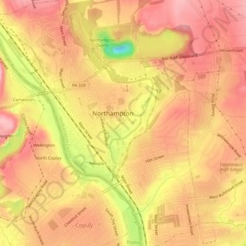
Name: Northampton topographic map, elevation, terrain.
Location: Northampton, Northampton County, Pennsylvania, United States (40.66687 -75.51586 40.70441 -75.47217)
Average elevation: 113 m
Minimum elevation: 11 m
Maximum elevation: 159 m
Make a donation
Other topographic maps
Click on a map to view its topography, its elevation and its terrain.
Weiders Crossing
United States > Pennsylvania > Northampton County > Lehigh Township
Average elevation: 218 m
Pennsville
United States > Pennsylvania > Northampton County > Lehigh Township
Average elevation: 191 m
Raubsville
United States > Pennsylvania > Northampton County > Williams Township
Average elevation: 102 m
Make a donation
Slateford
United States > Pennsylvania > Northampton County > Upper Mount Bethel Township
Average elevation: 192 m
Kesslersville
United States > Pennsylvania > Northampton County > Plainfield Township
Average elevation: 177 m
Make a donation
Stouts
United States > Pennsylvania > Northampton County > Williams Township > Stouts
Average elevation: 165 m
Green Pond
United States > Pennsylvania > Northampton County > Bethlehem Township
Average elevation: 124 m
Browntown
United States > Pennsylvania > Northampton County > Glendon > Browntown
Average elevation: 114 m
Make a donation
Butztown
United States > Pennsylvania > Northampton County > Bethlehem Township
Average elevation: 110 m