
Littoral topographic map
Interactive map
Click on the map to display elevation.
About this map
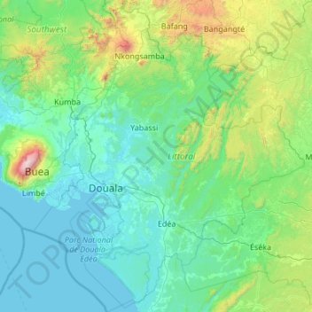
Name: Littoral topographic map, elevation, terrain.
Location: Littoral, Cameroon (3.18785 9.20522 5.33502 11.07755)
Average elevation: 383 m
Minimum elevation: -2 m
Maximum elevation: 3,987 m
Other topographic maps
Click on a map to view its topography, its elevation and its terrain.
Lake Bambili
Lake Bambili, Banja-Bambili-Babanki, Tubah, CUB, Mezam, Northwest, Cameroon
Average elevation: 2,295 m
Mount Cameroon
Mount Cameroon, Meme, Southwest, Cameroon
Average elevation: 3,645 m
Alantika Mountains
Alantika Mountains, Béka, Faro, North, Cameroon
Average elevation: 1,618 m
Bamendjing
Cameroon > West > Bamendjing
Bamendjing, Bamboutos, West, Cameroon
Average elevation: 1,168 m