
Make a donation
North topographic map
Click on the map to display elevation.
Make a donation
North
The Bénoué Depression constitutes the North Province's primary land feature. This basin runs along the Mayo Kébi and Bénoué River and has an elevation of between zero and 200 metres. The valleys surrounding the various rivers that feed the Kébi and later Bénoué reach elevations only slightly higher than this, averaging 200–500 metres in the north and 500–1000 metres in the south (the dividing line is at about 8˙ N). Garoua lies at about 235 metres. Farther north is the Kaélé Elevation. A major fault runs north of the Bénoué, roughly parallel to it.
Make a donation
About this map
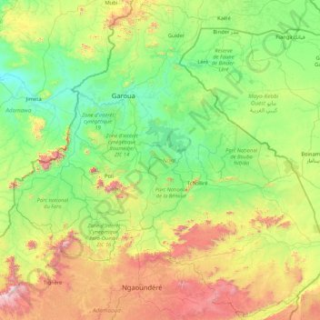
Name: North topographic map, elevation, terrain.
Location: North, Cameroon (7.01473 12.24380 10.25946 15.59145)
Average elevation: 554 m
Minimum elevation: 141 m
Maximum elevation: 2,318 m
Make a donation
Other topographic maps
Click on a map to view its topography, its elevation and its terrain.