
南岭国家森林公园 topographic map
Interactive map
Click on the map to display elevation.
About this map
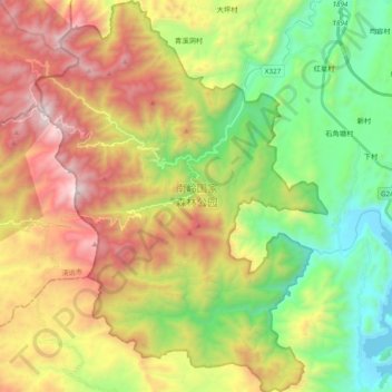
Name: 南岭国家森林公园 topographic map, elevation, terrain.
Location: 南岭国家森林公园, 天井山林场, 乳源瑶族自治县, 韶关市, 广东省, 中国 (24.80339 112.98610 24.97768 113.12942)
Average elevation: 905 m
Minimum elevation: 207 m
Maximum elevation: 1,871 m
南岭国家森林公园位于中國廣東省韶關市乳源瑶族自治县,近湖南莽山,地處南岭山脉的核心地带,是广东省最大的自然保护区,總面積約273平方公里。是珠江支流北江的发源地。海拔1902米的石坑崆是广东省最高峰。
Other topographic maps
Click on a map to view its topography, its elevation and its terrain.