
Cement Hill topographic map
Interactive map
Click on the map to display elevation.
About this map
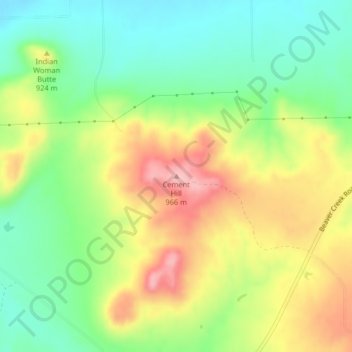
Name: Cement Hill topographic map, elevation, terrain.
Location: Cement Hill, Hill County, Montana, United States (48.49439 -109.71247 48.49449 -109.71237)
Average elevation: 882 m
Minimum elevation: 817 m
Maximum elevation: 968 m
Other topographic maps
Click on a map to view its topography, its elevation and its terrain.
Rocky Boy's Agency
United States > Montana > Hill County > Rocky Boy's Agency
Rocky Boy's Agency, Hill County, Montana, United States
Average elevation: 1,198 m
Havre
United States > Montana > Hill County > Havre
Havre, Hill County, Montana, 59501, United States
Average elevation: 849 m
Havre
United States > Montana > Hill County
Havre, Hill County, Montana, United States
Average elevation: 789 m