
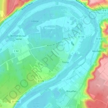
Tosny topographic map
Interactive map
Click on the map to display elevation.
About this map
Name: Tosny topographic map, elevation, terrain.
Average elevation: 38 m
Minimum elevation: 6 m
Maximum elevation: 150 m
La commune est riveraine de la Seine qui coule 25 mètres d'altitude plus bas.
Other topographic maps
Click on a map to view its topography, its elevation and its terrain.
Port-Morin
France > Normandie > Eure > Les Trois Lacs
Port-Morin, Tosny, Les Trois Lacs, Les Andelys, Eure, Normandie, France métropolitaine, 27700, France
Average elevation: 63 m
Venables
France > Normandie > Eure > Les Trois Lacs
Venables, Les Trois Lacs, Les Andelys, Eure, Normandie, France métropolitaine, 27940, France
Average elevation: 61 m
Bernières-sur-Seine
France > Normandie > Eure > Les Trois Lacs
Bernières-sur-Seine, Les Trois Lacs, Les Andelys, Eure, Normandie, France métropolitaine, 27700, France
Average elevation: 30 m