
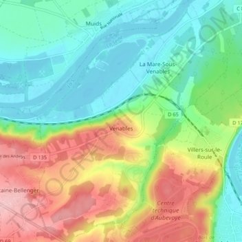
Venables topographic map
Interactive map
Click on the map to display elevation.
About this map
Name: Venables topographic map, elevation, terrain.
Average elevation: 61 m
Minimum elevation: 7 m
Maximum elevation: 151 m
Venables est située à l'extrême pointe nord du plateau de Madrie. Le village est construit sur un belvédère dont le point culminant se situe à 124 m d'altitude. Le site domine un méandre de la Seine.Hameaux. La Mare sous Venables, La Rive, Lormais, Le Moulin à Vent, Le Val d'Ailly et Fontaine la Verte.
Other topographic maps
Click on a map to view its topography, its elevation and its terrain.
Port-Morin
France > Normandie > Eure > Les Trois Lacs
Port-Morin, Tosny, Les Trois Lacs, Les Andelys, Eure, Normandie, France métropolitaine, 27700, France
Average elevation: 63 m
Tosny
France > Normandie > Eure > Les Trois Lacs
Tosny, Les Trois Lacs, Les Andelys, Eure, Normandie, France métropolitaine, 27700, France
Average elevation: 38 m
Bernières-sur-Seine
France > Normandie > Eure > Les Trois Lacs
Bernières-sur-Seine, Les Trois Lacs, Les Andelys, Eure, Normandie, France métropolitaine, 27700, France
Average elevation: 30 m