
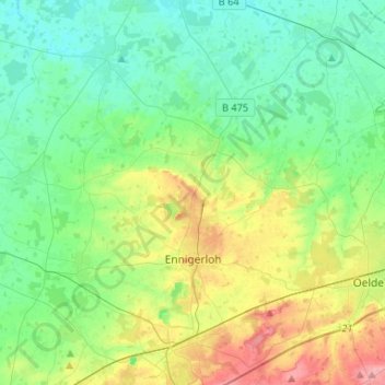
Ennigerloh topographic map
Interactive map
Click on the map to display elevation.
About this map
Name: Ennigerloh topographic map, elevation, terrain.
Average elevation: 82 m
Minimum elevation: 54 m
Maximum elevation: 149 m
Other topographic maps
Click on a map to view its topography, its elevation and its terrain.
Beckum
Germany > North Rhine-Westphalia > Kreis Warendorf
Beckum, Kreis Warendorf, North Rhine-Westphalia, 59269, Germany
Average elevation: 110 m
Wadersloh
Germany > North Rhine-Westphalia > Kreis Warendorf
Wadersloh, Kreis Warendorf, North Rhine-Westphalia, Germany
Average elevation: 87 m
Westkirchen
Germany > North Rhine-Westphalia > Kreis Warendorf > Ennigerloh
Westkirchen, Ennigerloh, Kreis Warendorf, North Rhine-Westphalia, 59320, Germany
Average elevation: 80 m