
Sherwood Park topographic map
Interactive map
Click on the map to display elevation.
About this map
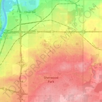
Name: Sherwood Park topographic map, elevation, terrain.
Location: Sherwood Park, Comté de Strathcona, Alberta, Canada (53.50475 -113.40161 53.59950 -113.24652)
Average elevation: 691 m
Minimum elevation: 608 m
Maximum elevation: 753 m
Other topographic maps
Click on a map to view its topography, its elevation and its terrain.
Comté de Strathcona
Canada > Alberta > Comté de Strathcona
Comté de Strathcona, Alberta, Canada
Average elevation: 691 m