
Thank you for supporting this site ❤️
Make a donation
Make a donation
Góis topographic map
Click on the map to display elevation.
Thank you for supporting this site ❤️
Make a donation
Make a donation
About this map
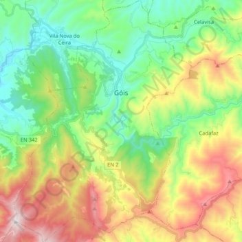
Name: Góis topographic map, elevation, terrain.
Location: Góis, Coimbra, Portugal (40.07929 -8.18039 40.20101 -8.06283)
Average elevation: 497 m
Minimum elevation: 102 m
Maximum elevation: 1,202 m
Thank you for supporting this site ❤️
Make a donation
Make a donation
Other topographic maps
Click on a map to view its topography, its elevation and its terrain.
Thank you for supporting this site ❤️
Make a donation
Make a donation