
Thank you for supporting this site ❤️
Make a donation
Make a donation
Rio Ceira topographic map
Click on the map to display elevation.
Thank you for supporting this site ❤️
Make a donation
Make a donation
About this map
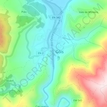
Name: Rio Ceira topographic map, elevation, terrain.
Location: Rio Ceira, São Paulo, Góis, Coimbra, 3330-304, Portugal (40.15363 -8.11216 40.15470 -8.11193)
Average elevation: 328 m
Minimum elevation: 179 m
Maximum elevation: 637 m
Thank you for supporting this site ❤️
Make a donation
Make a donation
Other topographic maps
Click on a map to view its topography, its elevation and its terrain.
Thank you for supporting this site ❤️
Make a donation
Make a donation