Geolocate

Dniester topographic map

Click on the map to display elevation.

About this map

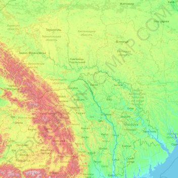
Name: Dniester topographic map, elevation, terrain.

Location: Dniester, Ukraine (46.30371 22.83268 49.59662 30.29986)

Average elevation: 349 m

Minimum elevation: -8 m

Maximum elevation: 2,485 m

Other topographic maps

Click on a map to view its topography, its elevation and its terrain.

Rivne

Ukraine > Rivne Oblast > Rivne

Average elevation: 214 m

Kyiv

Ukraine > Kyiv

Average elevation: 131 m

Mukachevo

Ukraine > Zakarpattia Oblast > Mukachevo

Average elevation: 142 m

Hoverla

Ukraine

In the 20th century, the mountain increasingly gained popularity as an extreme sports site. Some routes are classified as 1A in the winter period (from late autumn to May), according to the Soviet grading system. The most popular approach to the summit starts from the tour-basa Zarosliak on the mountain's…

Average elevation: 1,667 m

Victoria

Ukraine > Donetsk Oblast

Average elevation: 181 m

Kotivka

Ukraine > Sumy Oblast

Average elevation: 149 m

Chahiv

Ukraine > Vinnytsia Oblast

Average elevation: 255 m

Velykosilky

Ukraine > Lviv Oblast

Average elevation: 242 m

Pechykhvosty

Ukraine > Lviv Oblast

Average elevation: 234 m

Zemlianka

Ukraine > Sumy Oblast

Average elevation: 158 m

Pishchanka

Ukraine > Dnipropetrovsk Oblast

Average elevation: 58 m

Pluhatar

Ukraine > Dnipropetrovsk Oblast

Average elevation: 90 m

Andriivka

Ukraine > Sumy Oblast

Average elevation: 201 m

Stepnohirsk

Ukraine > Zaporizhia Oblast

Average elevation: 61 m

Stepnohirsk

Ukraine > Zaporizhia Oblast

Average elevation: 61 m

Hupalivka

Ukraine > Dnipropetrovsk Oblast

Average elevation: 74 m

Zelenyi Bir

Ukraine > Kyiv Oblast

Average elevation: 188 m

Shaian

Ukraine

Average elevation: 277 m

Zaliznychne

Ukraine > Zaporizhia Oblast

Average elevation: 141 m

Kuzemyn

Ukraine > Sumy Oblast

Average elevation: 180 m

Demuryne

Ukraine > Dnipropetrovsk Oblast

Average elevation: 162 m

Khotianivka

Ukraine > Kyiv Oblast

Average elevation: 97 m

Antonivka

Ukraine > Kherson Oblast

Average elevation: 5 m

Stratyn

Ukraine > Ivano-Frankivsk Oblast

Average elevation: 330 m

Krasiatychi

Ukraine > Kyiv Oblast

Average elevation: 145 m

Rodatychi

Ukraine > Lviv Oblast

Average elevation: 260 m

Borove

Ukraine > Lviv Oblast

Average elevation: 263 m

Zaporizhzhia

Ukraine

Average elevation: 26 m

Turia Bystra

Ukraine

Average elevation: 380 m

Novenke

Ukraine > Chernihiv Oblast

Average elevation: 183 m

Makivka

Ukraine > Lviv Oblast

Average elevation: 705 m

Снагость

Ukraine > Sumy Oblast > Volodymyrivka

Average elevation: 186 m

Sequoia

Ukraine

Average elevation: 607 m

Pokrovske

Ukraine > Dnipropetrovsk Oblast

Average elevation: 100 m

Mykolaivka

Ukraine > Dnipropetrovsk Oblast

Average elevation: 108 m

Dnipro

Ukraine > Chernihiv Oblast

The source of the Dnieper is the sedge bogs (Akseninsky Mokh) of the Valdai Hills in central Russia, at an elevation of 220 m (720 ft). For 115 km (71 mi) of its length, it serves as the border between Belarus and Ukraine. Its estuary, or liman, used to be defended by the strong fortress of Ochakiv.

Average elevation: 108 m

Kolodiivka

Ukraine > Khmelnytskyi Oblast

It is located in the southernmost portion of the oblast on the Dnister River at an elevation of 273 m (896 ft). The village maintains its own local government as the Kolodiivka Rural Council (Ukrainian: Колодіївська сільська рада), which consists of 21 locally elected deputies.

Average elevation: 252 m

Perevolochna

Ukraine > Chernihiv Oblast

Average elevation: 113 m

Bili Oslavy

Ukraine

Average elevation: 510 m

Kozari

Ukraine > Ivano-Frankivsk Oblast

Average elevation: 252 m

Betsylove

Ukraine > Odesa Oblast

Average elevation: 77 m

Rekity

Ukraine > Zakarpattia Oblast

Average elevation: 810 m

Prypiat River

Ukraine > Volyn Oblast

Average elevation: 142 m

Viktorivka

Ukraine > Odesa Oblast

Average elevation: 43 m

Mala Hlusha

Ukraine > Volyn Oblast

Average elevation: 151 m

Strilkiv

Ukraine > Lviv Oblast

Average elevation: 313 m

Koman

Ukraine > Ivano-Frankivsk Oblast

Average elevation: 1,484 m

Novoiehorivka

Ukraine > Kirovohrad Oblast

Average elevation: 199 m

Andriivka

Ukraine > Kharkiv Oblast

Average elevation: 94 m

Tymoshivka

Ukraine > Zaporizhia Oblast

Average elevation: 73 m

Mamalyha

Ukraine > Chernivtsi Oblast

Average elevation: 130 m

Sequoia

Ukraine

Average elevation: 607 m

Bilsk

Ukraine > Poltava Oblast

Average elevation: 171 m

Tatarbunary

Ukraine > Odesa Oblast

Average elevation: 20 m

Basivka

Ukraine > Lviv Oblast

The village covers an area of 2,39 km2 at an altitude of 305 metres (1,000 ft) above sea level. The population of village is just about 1042 persons and local government is administered by the Hodovytsko-Basivska village council.

Average elevation: 318 m

Krupoderyntsi

Ukraine > Poltava Oblast

Average elevation: 101 m

Dnipro

Ukraine > Chernihiv Oblast

The source of the Dnieper is the sedge bogs (Akseninsky Mokh) of the Valdai Hills in central Russia, at an elevation of 220 m (720 ft). For 115 km (71 mi) of its length, it serves as the border between Belarus and Ukraine. Its estuary, or liman, used to be defended by the strong fortress of Ochakiv.

Average elevation: 110 m

Pidpechery

Ukraine > Ivano-Frankivsk Oblast

Average elevation: 253 m

Luhovyky

Ukraine > Poltava Oblast

Average elevation: 138 m

Prypiat River

Ukraine > Volyn Oblast

Average elevation: 142 m

Solone

Ukraine > Dnipropetrovsk Oblast

Average elevation: 116 m

Lvove

Ukraine

Average elevation: 30 m

Sukha Balka

Ukraine > Mykolaiv Oblast

Average elevation: 116 m

Nalyvaikivka

Ukraine > Kyiv Oblast

Average elevation: 177 m

Korsak

Ukraine > Zaporizhia Oblast > Hannivka

Average elevation: 44 m

Luhovyky

Ukraine > Poltava Oblast

Average elevation: 138 m

Zoria

Ukraine > Rivne Oblast

Average elevation: 221 m

X

Ukraine > Lviv Oblast > Lviv

Average elevation: 335 m

Kamula

Ukraine > Lviv Oblast

Average elevation: 409 m

Kukul

Ukraine > Ivano-Frankivsk Oblast

Average elevation: 1,279 m

Karasynivka

Ukraine > Chernihiv Oblast

Average elevation: 114 m

Varachyne

Ukraine > Sumy Oblast

Average elevation: 205 m

Sosnova

Ukraine > Kyiv Oblast

Average elevation: 115 m

Kamianka

Ukraine > Zhytomyr Oblast

Average elevation: 215 m

Chervone

Ukraine > Zhytomyr Oblast

Average elevation: 235 m

Kozulka

Ukraine > Lviv Oblast

Average elevation: 298 m

Lypniazhka

Ukraine > Kirovohrad Oblast

Average elevation: 145 m

Zavallia

Ukraine > Khmelnytskyi Oblast

Average elevation: 208 m

Onufriivka

Ukraine > Kirovohrad Oblast

Average elevation: 107 m

Vodiane

Ukraine > Dnipropetrovsk Oblast

Vodiane or Vodyane (Ukrainian: Водяне) is a village in Pokrovsk Raion, Donetsk Oblast, Ukraine. In 2001, the population was 319 and the elevation is 177m. Up until 2020, the village was part of Yasynuvata Raion, until it was merged into Pokrovsk Raion.

Average elevation: 147 m

Tarasivka

Ukraine > Lviv Oblast

Average elevation: 252 m

Херсонес

Ukraine > Sevastopol > Sevastopol

Average elevation: 2 m

Херсонес

Ukraine > Sevastopol > Sevastopol

Average elevation: 2 m

Olan

Ukraine

Average elevation: 1,247 m

Dohmarivka

Ukraine

Average elevation: 22 m

Rusyvel

Ukraine > Rivne Oblast

Average elevation: 224 m

Myhove

Ukraine > Chernivtsi Oblast

Average elevation: 533 m

Dnieper River

Ukraine > Cherkasy Oblast

The source of the Dnieper is the sedge bogs (Akseninsky Mokh) of the Valdai Hills in central Russia, at an elevation of 220 m (720 ft). For 115 km (71 mi) of its length, it serves as the border between Belarus and Ukraine. Its estuary, or liman, used to be defended by the strong fortress of Ochakiv.

Average elevation: 83 m

Dnipro

Ukraine > Chernihiv Oblast

The source of the Dnieper is the sedge bogs (Akseninsky Mokh) of the Valdai Hills in central Russia, at an elevation of 220 m (720 ft). For 115 km (71 mi) of its length, it serves as the border between Belarus and Ukraine. Its estuary, or liman, used to be defended by the strong fortress of Ochakiv.

Average elevation: 110 m

Rude Selo

Ukraine > Kyiv Oblast

Average elevation: 205 m

Dobriany

Ukraine

Average elevation: 289 m