Geolocate

Kyiv topographic map

Click on the map to display elevation.

Kyiv

Originally on the west bank, today Kyiv is on both sides of the Dnieper, which flows southwards through the city towards the Black Sea. The older and higher western part of the city sits on numerous wooded hills (Kyiv Hills), with ravines and small rivers. Kyiv's geographical relief contributed to its toponyms, such as Podil ("lower"), Pechersk ("caves"), and uzviz (a steep street, "descent"). Kyiv is a part of the larger Dnieper Upland adjoining the western bank of the Dnieper in its mid-flow, and which contributes to the city's elevation change.

Wikipedia (CC-BY-SA 3.0)

About this map

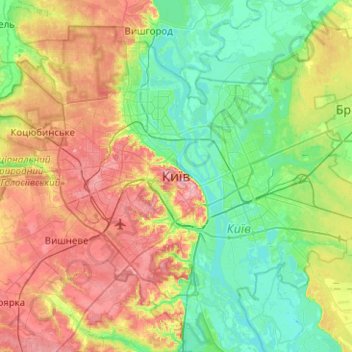
Name: Kyiv topographic map, elevation, terrain.

Location: Kyiv, Ukraine (50.29003 30.36414 50.61003 30.68414)

Average elevation: 131 m

Minimum elevation: 87 m

Maximum elevation: 210 m

Other topographic maps

Click on a map to view its topography, its elevation and its terrain.

Kyiv

Ukraine

Originally on the west bank, today Kyiv is on both sides of the Dnieper, which flows southwards through the city towards the Black Sea. The older and higher western part of the city sits on numerous wooded hills (Kyiv Hills), with ravines and small rivers. Kyiv's geographical relief contributed to its…

Average elevation: 133 m

Kostiantynivka

Ukraine > Cherkasy Oblast

Average elevation: 130 m

Ocheretyne

Ukraine > Donetsk Oblast

Average elevation: 227 m

Avdiivka

Ukraine > Donetsk Oblast

Average elevation: 206 m

Odesa Oblast

Ukraine

Average elevation: 86 m

16

Ukraine > Luhansk Oblast > Luhansk

Average elevation: 114 m

Saltivskyi district

Ukraine > Kharkiv Oblast > Kharkiv

Average elevation: 148 m

Robotyne

Ukraine > Zaporizhia Oblast

Average elevation: 140 m

Snake Island

Ukraine > Odesa Oblast > Bile

Average elevation: 0 m

Бокова

Ukraine > Kirovohrad Oblast

Average elevation: 129 m