
Abbot Pass Hut topographic map
Interactive map
Click on the map to display elevation.
About this map
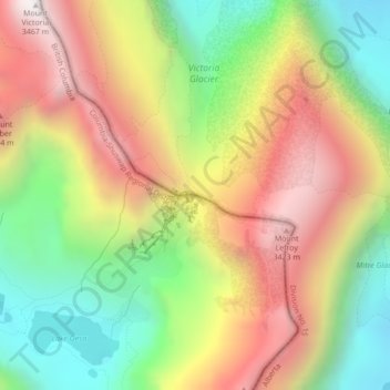
Name: Abbot Pass Hut topographic map, elevation, terrain.
Average elevation: 2,789 m
Minimum elevation: 2,186 m
Maximum elevation: 3,444 m
The approach via Lake O'Hara is by far the most popular route into the hut. It is safer and less technical than going in via the Deathtrap or the Fuhrmann Ledges. It involves about 900 metres (3,000 feet) of elevation gain and 3 to 5+ hours from Lake O'Hara to the hut depending on conditions and the strength of the party. People should not automatically assume they can always get to the hut, since some groups have been caught out overnight on the trail or stranded at the hut in bad weather conditions.
Other topographic maps
Click on a map to view its topography, its elevation and its terrain.
Lake O'Hara
Canada > British Columbia > Area A (Kicking Horse/Kinbasket Lake)
Lake O'Hara, Area A (Kicking Horse/Kinbasket Lake), Columbia-Shuswap Regional District, British Columbia, Canada
Average elevation: 2,277 m