
Μετέωρα topographic map
Interactive map
Click on the map to display elevation.
About this map
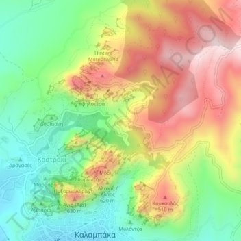
Name: Μετέωρα topographic map, elevation, terrain.
Average elevation: 429 m
Minimum elevation: 227 m
Maximum elevation: 678 m
Die Felsen von Meteora zählen zu den beliebtesten Kletterzielen in Griechenland. Der klettertechnische Erschließer des Gebietes ist hauptsächlich der Deutsche Dietrich Hasse, der auch Führerliteratur zu Wanderwegen und Kletterrouten in Meteora verfasst hat. 2001 sprang der Base-Jumper Felix Baumgartner aus 120 Meter Höhe von einem der Meteora-Felsen.
Other topographic maps
Click on a map to view its topography, its elevation and its terrain.
Kastraki
Griechenland > Thessalien - Mittelgriechenland > Regionalbezirk Trikala > Kastraki
Kastraki, Δήμος Μετεώρων, Regionalbezirk Trikala, Region Thessalien, Thessalien - Mittelgriechenland, 42200, Griechenland
Average elevation: 328 m