
Kastraki topographic map
Interactive map
Click on the map to display elevation.
About this map
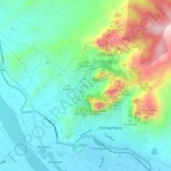
Name: Kastraki topographic map, elevation, terrain.
Average elevation: 328 m
Minimum elevation: 196 m
Maximum elevation: 674 m
Other topographic maps
Click on a map to view its topography, its elevation and its terrain.
Μετέωρα
Griechenland > Thessalien - Mittelgriechenland > Regionalbezirk Trikala > Kastraki
Μετέωρα, Kastraki, Δήμος Μετεώρων, Regionalbezirk Trikala, Region Thessalien, Thessalien - Mittelgriechenland, 422 00, Griechenland
Average elevation: 429 m