
Ghebala topographic map
Interactive map
Click on the map to display elevation.
About this map
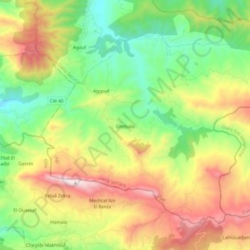
Name: Ghebala topographic map, elevation, terrain.
Location: Ghebala, Daïra Settara, Jijel, Algérie (36.57063 6.32596 36.68728 6.51053)
Average elevation: 616 m
Minimum elevation: 93 m
Maximum elevation: 1,442 m
Other topographic maps
Click on a map to view its topography, its elevation and its terrain.
Settara
Algérie > Jijel > Daïra Settara
Settara, Daïra Settara, Jijel, 18113, Algérie
Average elevation: 316 m