
Make a donation
Mbeya Region topographic map
Click on the map to display elevation.
Make a donation
Mbeya Region
The Great Rift Valley created the majority of the places in the area, with the lowland elevation occupying the Western Rift Zone, which includes the Lake Rukwa and Lake Nyasa regions, and the Eastern Rift Zone, which includes the Usangu Plains and other sections of the Ruaha Trough. The heights range from 475 meters above sea level at Lake Nyasa to more than 2,900 meters at Mount Rungwe's summit.
Make a donation
About this map
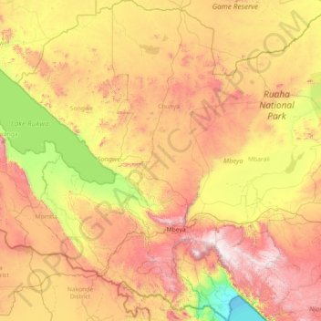
Name: Mbeya Region topographic map, elevation, terrain.
Location: Mbeya Region, Southern Highlands Zone, Tanzania (-9.71887 32.89446 -6.86722 34.96885)
Average elevation: 1,314 m
Minimum elevation: 473 m
Maximum elevation: 2,901 m
Make a donation
Other topographic maps
Click on a map to view its topography, its elevation and its terrain.
Dodoma
Tanzania > Dodoma Region > Dodoma
The official capital since 1996, Dodoma was envisaged as the first non-monumental capital city as opposed to the monumentality and hierarchy of other planned capital cities such as Abuja, Brasília and Washington, D.C. It rejected geometrical forms such as grid iron and radial plans as inappropriate as the…
Average elevation: 1,145 m
Make a donation