
Lake District National Park topographic map
Interactive map
Click on the map to display elevation.
Lake District National Park
The Lake District is a roughly circular upland massif, deeply dissected by a broadly radial pattern of major valleys which are largely the result of repeated glaciations over the last 2 million years. The apparent radial pattern is not from a central dome, but from an axial watershed extending from St Bees Head in the west to Shap in the east. Most of these valleys display the U-shaped cross-section characteristic of glacial origin and often contain long narrow lakes in bedrock hollows, with tracts of relatively flat ground at their infilled heads, or where they are divided by lateral tributaries (Buttermere-Crummock Water; Derwent Water-Bassenthwaite Lake). Smaller lakes known as tarns occupy glacial cirques at higher elevations. It is the abundance of both which has led to the area becoming known as the Lake District.
About this map
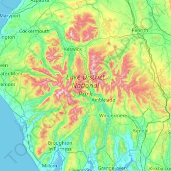
Name: Lake District National Park topographic map, elevation, terrain.
Location: Lake District National Park, England, United Kingdom (54.19333 -3.49567 54.76368 -2.58259)
Average elevation: 206 m
Minimum elevation: 0 m
Maximum elevation: 962 m
Other topographic maps
Click on a map to view its topography, its elevation and its terrain.
Lydney Harbour
United Kingdom > England > Gloucestershire > Forest of Dean > Lydney > Naas
Average elevation: 7 m
Hyde Park
United Kingdom > England > London
"It consists of a screen of handsome fluted Ionic columns, with three carriage entrance archways, two-foot entrances, a lodge, etc. The extent of the whole frontage is about 107 ft (33 m). The central entrance has a bold projection: the entablature is supported by four columns; and the volutes of the capitals…
Average elevation: 25 m
Malvern
United Kingdom > England > Worcestershire > Malvern Hills
Malvern lies in the Lower Severn/Avon plain affording it a degree of shelter caused by virtue of its nestling in between the Cotswold hills to the east, the Welsh Hills and Mountains to the west, and Birmingham plateau to the north. Although as with all the British Isles it has a maritime climate, the local…
Average elevation: 95 m
Highbury
United Kingdom > England > Gloucestershire > Forest of Dean > Lydney > Allaston
Average elevation: 68 m
Plymouth
United Kingdom > England > Devon > Plymouth
The River Plym, which flows off Dartmoor to the north-east, forms a smaller estuary to the east of the city called Cattewater. Plymouth Sound is protected from the sea by the Plymouth Breakwater, in use since 1814. In the Sound is Drake's Island which is seen from Plymouth Hoe, a flat public area on top of…
Average elevation: 81 m
Allesley
United Kingdom > England > West Midlands Combined Authority > Coventry > Allesley
Average elevation: 115 m