Geolocate

Moremi Game Reserve topographic map

Interactive map

Click on the map to display elevation.

About this map

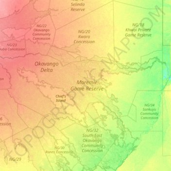
Name: Moremi Game Reserve topographic map, elevation, terrain.

Location: Moremi Game Reserve, North-West District, Botswana (-19.60540 22.55455 -18.98623 23.88218)

Average elevation: 951 m

Minimum elevation: 929 m

Maximum elevation: 979 m

Other topographic maps

Click on a map to view its topography, its elevation and its terrain.

Okavango Delta

Botswana > North-West District

Okavango Delta, North-West District, Botswana

Average elevation: 955 m

Shashe river

Botswana > North-West District > Maun

Shashe river, Maun, North-West District, P.O. BOX 217, Botswana

Average elevation: 941 m

Thamalakane River

Botswana > North-West District > Maun

Thamalakane River, Maun, North-West District, P.O. BOX 217, Botswana

Average elevation: 942 m

Maun

Botswana > North-West District > Maun

Maun, North-West District, Botswana

Average elevation: 942 m

Hambukushu

Botswana > North-West District > Hambukushu

Hambukushu, North-West District, Botswana

Average elevation: 1,017 m

Khwai

Botswana > North-West District > Khwai

Khwai, North-West District, Botswana

Average elevation: 939 m