
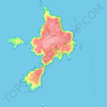
Sark topographic map
Interactive map
Click on the map to display elevation.
About this map
Name: Sark topographic map, elevation, terrain.
Location: Sark, Guernsey (49.40005 -2.39539 49.45229 -2.33785)
Average elevation: 12 m
Minimum elevation: 0 m
Maximum elevation: 106 m
Other topographic maps
Click on a map to view its topography, its elevation and its terrain.
abreuvoir of Saint Peter Port and Saint Martins
Guernsey > Guernsey > St Peter Port
Average elevation: 60 m
abreuvoir of Saint Peter Port and Saint Martins
Guernsey > Guernsey > St Peter Port
Average elevation: 60 m