
弥勒市 topographic map
Interactive map
Click on the map to display elevation.
About this map
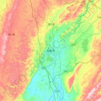
Name: 弥勒市 topographic map, elevation, terrain.
Location: 弥勒市, 红河哈尼族彝族自治州, 云南省, 中国 (24.25392 103.25270 24.57392 103.57270)
Average elevation: 1,748 m
Minimum elevation: 1,361 m
Maximum elevation: 2,287 m
Other topographic maps
Click on a map to view its topography, its elevation and its terrain.