
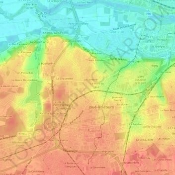
Le Clos Neuf topographic map
Interactive map
Click on the map to display elevation.
About this map
Name: Le Clos Neuf topographic map, elevation, terrain.
Average elevation: 74 m
Minimum elevation: 41 m
Maximum elevation: 99 m
Other topographic maps
Click on a map to view its topography, its elevation and its terrain.
Les Bercelleries
France > Centre-Val de Loire > Indre-et-Loire > Joué-lès-Tours
Les Bercelleries, Joué-lès-Tours, Tours, Indre-et-Loire, Centre-Val de Loire, France métropolitaine, 37300, France
Average elevation: 90 m
La Gare
France > Centre-Val de Loire > Indre-et-Loire > Joué-lès-Tours
La Gare, Joué-lès-Tours, Arrondissement de Tours, Indre-et-Loire, Centre-Val de Loire, France métropolitaine, 37300, France
Average elevation: 76 m
Manoir de Chérizy
France > Centre-Val de Loire > Indre-et-Loire > Joué-lès-Tours
Manoir de Chérizy, Rue de Chérisy, Le Val Violet, Joué-lès-Tours, Tours, Indre-et-Loire, Centre-Val de Loire, France métropolitaine, 37300, France
Average elevation: 73 m