
Thank you for supporting this site ❤️
Make a donation
Make a donation
La Gare topographic map
Click on the map to display elevation.
Thank you for supporting this site ❤️
Make a donation
Make a donation
About this map
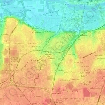
Name: La Gare topographic map, elevation, terrain.
Average elevation: 76 m
Minimum elevation: 42 m
Maximum elevation: 101 m
Thank you for supporting this site ❤️
Make a donation
Make a donation
Other topographic maps
Click on a map to view its topography, its elevation and its terrain.
Parc du Lac des Bretonnières
France > Centre-Val de Loire > Indre-et-Loire > Joué-lès-Tours > La Petite Carte
Average elevation: 85 m