
Mangnai topographic map
Interactive map
Click on the map to display elevation.
About this map
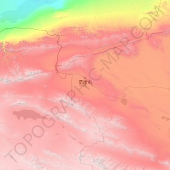
Name: Mangnai topographic map, elevation, terrain.
Location: Mangnai, Haixi, Qinghai, 816400, China (37.02047 90.10776 39.17917 94.28663)
Average elevation: 3,237 m
Minimum elevation: 791 m
Maximum elevation: 5,919 m
Other topographic maps
Click on a map to view its topography, its elevation and its terrain.
ཏུའུ་ལན་རྫོང་ 都兰县
ཏུའུ་ལན་རྫོང་ 都兰县, མཚོ་ནུབ་སོག་རིགས་ཆ་བོད་རིགས་རང་སྐྱོང་ཁུལ་ 海西蒙古族藏族自治州, Qinghai, China
Average elevation: 3,814 m
Hoh Xil Shan
China > Qinghai > ཟོ་སྐྱ 索加乡
Hoh Xil Shan, ཟོ་སྐྱ 索加乡, འབྲི་སྟོད་རྫོང་治多县, 玉树州, Qinghai, China
Average elevation: 5,203 m
Bayan-Har-Gebirge
Bayan-Har-Gebirge, 玛多县, རྨ་སྟོད་རྫོང་ 玛多县, 果洛州, Qinghai, China
Average elevation: 4,304 m
Qinghai-See
Qinghai-See, གསེར་ཆེན་རྫོང 共和县, 海南州, Qinghai, China
Average elevation: 3,332 m