
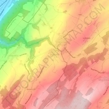
Sédeilles topographic map
Interactive map
Click on the map to display elevation.
About this map
Name: Sédeilles topographic map, elevation, terrain.
Average elevation: 691 m
Minimum elevation: 462 m
Maximum elevation: 819 m
Other topographic maps
Click on a map to view its topography, its elevation and its terrain.
Salavaux
Suisse > Vaud > District de la Broye-Vully > Vully-les-Lacs
Salavaux, Vully-les-Lacs, District de la Broye-Vully, Vaud, 1585, Suisse
Average elevation: 473 m
Prévonloup
Suisse > Vaud > District de la Broye-Vully
Prévonloup, District de la Broye-Vully, Vaud, Suisse
Average elevation: 744 m
Chabrey
Suisse > Vaud > District de la Broye-Vully > Vully-les-Lacs
Chabrey, Vully-les-Lacs, District de la Broye-Vully, Vaud, 1589, Suisse
Average elevation: 477 m
Brenles
Suisse > Vaud > District de la Broye-Vully
Brenles, Lucens, District de la Broye-Vully, Vaud, 1522, Suisse
Average elevation: 776 m
Vulliens
Suisse > Vaud > District de la Broye-Vully
Vulliens, District de la Broye-Vully, Vaud, 1085, Suisse
Average elevation: 666 m
Cremin
Suisse > Vaud > District de la Broye-Vully
Cremin, Lucens, District de la Broye-Vully, Vaud, 1526, Suisse
Average elevation: 590 m
Cudrefin
Suisse > Vaud > District de la Broye-Vully
Cudrefin, District de la Broye-Vully, Vaud, 1588, Suisse
Average elevation: 457 m
Villarzel
Suisse > Vaud > District de la Broye-Vully
Villarzel, District de la Broye-Vully, Vaud, Suisse
Average elevation: 669 m
Payerne
Suisse > Vaud > District de la Broye-Vully
Payerne, District de la Broye-Vully, Vaud, Suisse
Average elevation: 495 m
Combremont-le-Petit
Suisse > Vaud > District de la Broye-Vully > Valbroye
Combremont-le-Petit, Valbroye, District de la Broye-Vully, Vaud, 1536, Suisse
Average elevation: 676 m
Cerniaz
Suisse > Vaud > District de la Broye-Vully > Valbroye
Cerniaz, Valbroye, District de la Broye-Vully, Vaud, 1525, Suisse
Average elevation: 658 m
Oulens-sur-Lucens
Suisse > Vaud > District de la Broye-Vully > Lucens
Oulens-sur-Lucens, Lucens, District de la Broye-Vully, Vaud, 1522, Suisse
Average elevation: 655 m
La Broye
Suisse > Vaud > District de la Broye-Vully
La Broye, District de la Broye-Vully, Vaud, Suisse
Average elevation: 735 m
Moudon
Suisse > Vaud > District de la Broye-Vully
Moudon, District de la Broye-Vully, Vaud, 1510, Suisse
Average elevation: 674 m
Champmartin
Suisse > Vaud > District de la Broye-Vully > Cudrefin
Champmartin, Cudrefin, District de la Broye-Vully, Vaud, 1588, Suisse
Average elevation: 475 m
Faoug
Suisse > Vaud > District de la Broye-Vully
Faoug, District de la Broye-Vully, Vaud, 1595, Suisse
Average elevation: 447 m
Oleyres
Suisse > Vaud > District de la Broye-Vully > Avenches
Oleyres, Avenches, District de la Broye-Vully, Vaud, Suisse
Average elevation: 564 m
Corcelles-le-Jorat
Suisse > Vaud > District de la Broye-Vully
Corcelles-le-Jorat, District de la Broye-Vully, Vaud, 1082, Suisse
Average elevation: 812 m
Avenches
Suisse > Vaud > District de la Broye-Vully
Avenches, District de la Broye-Vully, Vaud, 1580, Suisse
Average elevation: 487 m
Lucens
Suisse > Vaud > District de la Broye-Vully
Lucens, District de la Broye-Vully, Vaud, 1522, Suisse
Average elevation: 672 m
Corcelles-près-Payerne
Suisse > Vaud > District de la Broye-Vully
Corcelles-près-Payerne, District de la Broye-Vully, Vaud, 1562, Suisse
Average elevation: 458 m
Granges-près-Marnand
Suisse > Vaud > District de la Broye-Vully > Valbroye
Granges-près-Marnand, Valbroye, District de la Broye-Vully, Vaud, 1523, Suisse
Average elevation: 517 m
Valbroye
Suisse > Vaud > District de la Broye-Vully
Valbroye, District de la Broye-Vully, Vaud, Suisse
Average elevation: 622 m