
Make a donation
Vienna topographic map
Click on the map to display elevation.
Make a donation
Vienna
Vienna is located in northeastern Austria, at the easternmost extension of the Alps in the Vienna Basin. The earliest settlement, at the location of today's inner city, was south of the meandering Danube while the city now spans both sides of the river. Elevation ranges from 151 to 542 m (495 to 1,778 ft). The city has a total area of 414.65 square kilometers (160.1 sq mi), making it the largest city in Austria by area.
Make a donation
About this map
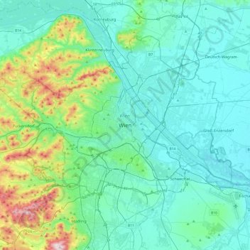
Name: Vienna topographic map, elevation, terrain.
Location: Vienna, 1010, Austria (48.04835 16.21250 48.36835 16.53250)
Average elevation: 231 m
Minimum elevation: 145 m
Maximum elevation: 650 m
Make a donation
Other topographic maps
Click on a map to view its topography, its elevation and its terrain.
Vienna
Vienna is located in northeastern Austria, at the easternmost extension of the Alps in the Vienna Basin. The earliest settlement, at the location of today's inner city, was south of the meandering Danube while the city now spans both sides of the river. Elevation ranges from 151 to 542 m (495 to 1,778 ft). The…
Average elevation: 227 m
Make a donation
Zell am See
Austria > Salzburg > Bezirk Zell am See
Zell am See provides winter skiing on the above Schmittenhöhe mountain. The skiable area is approximately 138 km, including the pistes on the Kitzsteinhorn and Kaprun Maiskogel. The ski pass covers the whole area including transport to and from the glacier which is open most of the year, dependent on…
Average elevation: 1,118 m
Vienna
Vienna is located in northeastern Austria, at the easternmost extension of the Alps in the Vienna Basin. The earliest settlement, at the location of today's inner city, was south of the meandering Danube while the city now spans both sides of the river. Elevation ranges from 151 to 542 m (495 to 1,778 ft). The…
Average elevation: 227 m
Graz
Graz is situated on both sides of the river Mur in southeast Austria. It is about 150 km (93 mi) southwest of Vienna (Wien). The nearest larger urban centre is Maribor (Marburg) in Slovenia, which is about 50 km (31 mi) to the south. Graz is the capital of Styria and the largest city in the federal state, a…
Average elevation: 426 m
Make a donation
Vienna
Vienna is located in northeastern Austria, at the easternmost extension of the Alps in the Vienna Basin. The earliest settlement, at the location of today's inner city, was south of the meandering Danube, while the city now spans both sides of the river. Elevation ranges from 151 to 542 m (495 to 1,778 ft).…
Average elevation: 227 m
Schneeberg
Austria > Lower Austria > Bezirk Neunkirchen > Schwarzau im Gebirge
A rack-and-pinion railway, the Schneeberg Railway, now over 100 years old, climbs to a height of 1,800 m (5,900 ft), reducing the walk to the summit to an hour or two. There are also a number of other routes for walkers, including from the spa resort of Puchberg am Schneeberg to the east, or from the south, in…
Average elevation: 1,081 m
Make a donation
Make a donation
Make a donation
Make a donation
Kaprun
Austria > Salzburg > Bezirk Zell am See
Kaprun (German pronunciation: [kaˈpruːn]) is a municipality in the Zell am See District in the province of Salzburg in Austria. Together with the neighboring city of Zell am See the town presents itself as the tourist destination and skiing area "Zell am See-Kaprun". Kaprun distinguishes itself from its…
Average elevation: 1,819 m
Make a donation
Graz
Graz is situated on both sides of the Mur river in southeast Austria. It is about 150 km (93 mi) southwest of Vienna (Wien). The nearest larger urban centre is Maribor (Marburg) in Slovenia, which is about 50 km (31 mi) to the south. Graz is the state capital and largest city in Styria, a green and heavily…
Average elevation: 426 m
Make a donation
Make a donation
Sankt Sigmund im Sellrain
Austria > Tyrol > Bezirk Innsbruck-Land
Sankt Sigmund im Sellrain is a municipality in western Austria, in the district of Innsbruck-Land in the state of Tyrol located 23.3 kilometres (14.5 mi) southeast of Innsbruck, in the deepest part of the Sellrain Valley. It has a large area and the highest elevation. The main source of income is winter…
Average elevation: 2,289 m
Make a donation
Zell am See
Austria > Salzburg > Bezirk Zell am See
Zell am See provides winter skiing on the above Schmittenhöhe mountain. The skiable area is around 138 km, including the pistes on the Kitzsteinhorn and Kaprun Maiskogel. The ski pass covers the whole area including transport to and from the glacier, which is open most of the year, dependent on snowfall. Zell…
Average elevation: 1,118 m
Ischgl
Austria > Tyrol > Bezirk Landeck
Ischgl has a weather station at an altitude of 2,327 m (7,635 ft). This weather station is located within the alpine climate zone (Köppen ETH), closely bordering on a subarctic climate (Köppen Dfc), because the hottest month is only 9.9 °C (49.8 °F).
Average elevation: 2,251 m
Make a donation
Pasterze
Austria > Carinthia > Bezirk Spittal an der Drau > Heiligenblut am Großglockner
Average elevation: 2,599 m
Sölden
Austria > Tyrol > Bezirk Imst
The main village of Sölden is at an elevation of 1,368 metres (4,488 ft) above sea level, and the upper village of Hochsölden at 2,090 m (6,857 ft) has 5 four-star hotels. The highest peak is the Wildspitze, at 3,768 m (12,362 ft), the second highest mountain in Austria, after the Großglockner.
Average elevation: 2,483 m
Fischbach
Austria > Styria > Bezirk Weiz
Fischbach is a town in the Fischbacher Alpen and is located about 12 km (7.5 mi) northwest of Birkfeld and about 27 km (17 mi) air-line distance from the district capital Weiz. The maximum north-south extension as well as the maximum east-west extension are each about nine kilometers (5.6 mi). The municipality…
Average elevation: 1,024 m
Make a donation
Fürstenfeld
Austria > Styria > Bezirk Hartberg-Fürstenfeld
Fürstenfeld is located in the lower Feistritz [ceb; de; sh; sv] valley near the Burgenland border. Elevation of the urban area ranges from 255m to approximately 300 m ü. A. The city`s central part sits on a river terrace two dozen meters above the valley floor.
Average elevation: 283 m
Wachau Cultural Landscape
Austria > Lower Austria > Bezirk Krems
The Danube valley in Austria between the cities of Melk and Krems in Lower Austria is called the Wachau. This stretch of the valley includes the hills and the adjacent Dunkelsteiner Wald (Dunkelsteiner Forest) and the southern Waldviertel. The Danube river flows north-northeast from Melk to Dürnstein through…
Average elevation: 486 m
Make a donation
Make a donation
Hallstatt
Austria > Upper Austria > Bezirk Gmunden
The Hallstatt salt mine is the world's oldest working salt mine. The mine is located within the Upper Permian to Lower Triassic Haselgebirge Formation of the Northern Limestone Alps. The Hallstatt salt mine comprises 21 levels and several smaller shafts ranging from 514 m above sea level (Erbstollen level) to…
Average elevation: 1,514 m
Make a donation
Make a donation
Make a donation
Make a donation
Nauders
Austria > Tyrol > Bezirk Landeck
The town lies in the valley of the Stillebach (a tributary of the Inn) in the Ötztal Alps, at an altitude of 1,394 m (4,573 ft). It is located about 29 km (18 mi) south of the district capital Landeck, on the road that leads from Pfunds in the Inntal valley via the narrow Finstermünz Gorge up to Reschen Pass…
Average elevation: 1,938 m
2630
Austria > Lower Austria > Bezirk Neunkirchen > Bürg-Vöstenhof > Ternitz > Pottschach
Average elevation: 664 m
Make a donation
Make a donation
Wallersee
Austria > Salzburg > Bezirk Salzburg-Umgebung > Seekirchen am Wallersee > Fischtaging
Average elevation: 531 m
Make a donation
Make a donation
Bad Gastein
Bad Gastein has a humid continental climate (Dfb) bordering on a subarctic climate (Dfc) due to the town's high elevation. Summers are mild, sometimes warm with cool, refreshing nights. Winters are moderately cold and snowy, with annual snowfall averaging 345 cm (136 inches).
Average elevation: 1,929 m
Make a donation
High Tauern National Park
The best-known mountain pass road of the High Tauern is the scenic Grossglockner High Alpine Road inaugurated in 1935, including a tunnel at an elevation of 2,505 metres (8,219 ft) under the Hochtor Pass (2,573 metres (8,442 ft)). East of it, the Katschberg Pass (1,641 metres (5,384 ft)) on B 99 Katschberg…
Average elevation: 1,710 m
Nationalpark Kalkalpen
Austria > Upper Austria > Bezirk Kirchdorf
Kalkalpen National Park has visitors centers in Molln, Ennstal, and at the Hengstpaßhütt near Rosenau. The Wurbauerkogel, a 21 metres (69 ft) high panorama view tower, is located near Windischgarsten. It is accessible by a chair lift and hiking paths. In clear weather 21 peaks of 2,000 metres (6,600 ft) or…
Average elevation: 952 m
Make a donation
Vienna
Vienna is located in northeastern Austria, at the easternmost extension of the Alps in the Vienna Basin. The earliest settlement, at the location of today's inner city, was south of the meandering Danube, while the city now spans both sides of the river. Elevation ranges from 151 to 542 m (495 to 1,778 ft).…
Average elevation: 227 m
Altenberg bei Linz
Austria > Upper Austria > Bezirk Urfahr-Umgebung
Located on a southern part of the Zentralmühlviertler Hochland [de] at an altitude of 592 meters, the municipality has a view over the Mühlviertel region, Linz, the capital of Upper Austria as well as the so-called Zentralland and even the foothills of the Northern Limestone Alps. Because of that, it has…
Average elevation: 573 m
Make a donation