
Hasselfelde topographic map
Interactive map
Click on the map to display elevation.
About this map
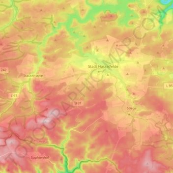
Name: Hasselfelde topographic map, elevation, terrain.
Average elevation: 494 m
Minimum elevation: 301 m
Maximum elevation: 617 m
Other topographic maps
Click on a map to view its topography, its elevation and its terrain.
Schierke
Germany > Saxony-Anhalt > Landkreis Harz > Wernigerode
Schierke, Wernigerode, Landkreis Harz, Saxony-Anhalt, 38879, Germany
Average elevation: 707 m
Thale
Germany > Saxony-Anhalt > Landkreis Harz > Thale
Thale, Landkreis Harz, Saxony-Anhalt, 06502, Germany
Average elevation: 304 m
Brocken
Germany > Saxony-Anhalt > Landkreis Harz > Wernigerode
Brocken, Wernigerode, Landkreis Harz, Saxony-Anhalt, Germany
Average elevation: 963 m
Wernigerode
Germany > Saxony-Anhalt > Landkreis Harz
Wernigerode, Landkreis Harz, Saxony-Anhalt, Germany
Average elevation: 381 m