
Cairn Gorm topographic map
Interactive map
Click on the map to display elevation.
Cairn Gorm
Cairn Gorm (Cairngorm) (Scottish Gaelic: An Càrn Gorm, meaning The Blue Hill) is a mountain in the Scottish Highlands overlooking Strathspey and the town of Aviemore. Cairn Gorm has a summit elevation of 1,245 metres (4,084 feet) AMSL and is the seventh-highest mountain in both the United Kingdom and the British Isles. Cairn Gorm gives its name to the mountain range and the National Park of which it is a part, The Cairngorms, despite that it is neither the highest nor the most prominent mountain in the range. These mountains were historically known as Am Monadh Ruadh (the Red Hills) rather than the Cairngorms. The domed summit of Cairn Gorm is one of the most readily identifiable mountains in the view from Aviemore.
About this map
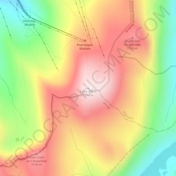
Name: Cairn Gorm topographic map, elevation, terrain.
Location: Cairn Gorm, Highland, Scotland, PH22 1RB, United Kingdom (57.11662 -3.64494 57.11672 -3.64484)
Average elevation: 989 m
Minimum elevation: 694 m
Maximum elevation: 1,244 m
Other topographic maps
Click on a map to view its topography, its elevation and its terrain.
Orkney Islands
United Kingdom > Scotland > Nesstoun
The southern group of islands surrounds Scapa Flow. Hoy is the second largest of the Orkney Isles and Ward Hill at its northern end is the highest elevation in the archipelago. The Old Man of Hoy is a well-known seastack. Burray lies to the east of Scapa Flow and is linked by causeway to South Ronaldsay, which…
Average elevation: 9 m