
Dumfries and Galloway topographic map
Interactive map
Click on the map to display elevation.
About this map
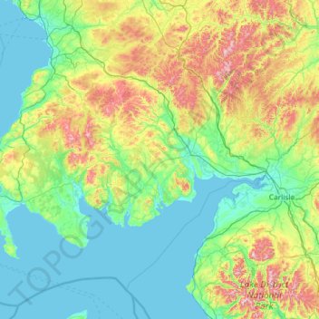
Name: Dumfries and Galloway topographic map, elevation, terrain.
Location: Dumfries and Galloway, Scotland, United Kingdom (54.63324 -5.18765 55.46405 -2.85733)
Average elevation: 163 m
Minimum elevation: -1 m
Maximum elevation: 921 m
Other topographic maps
Click on a map to view its topography, its elevation and its terrain.
Crawford
United Kingdom > Scotland > South Lanarkshire
Crawford, South Lanarkshire, Scotland, ML12 6TP, United Kingdom
Average elevation: 314 m
Kirkwall
United Kingdom > Scotland > Orkney Islands
Kirkwall, Orkney Islands, Scotland, KW15 1DH, United Kingdom
Average elevation: 27 m
Port William
United Kingdom > Scotland > Dumfries and Galloway
Port William, Dumfries and Galloway, Scotland, DG8 9SJ, United Kingdom
Average elevation: 17 m
Kintore
United Kingdom > Scotland > Aberdeenshire
Kintore, Aberdeenshire, Scotland, AB51 0US, United Kingdom
Average elevation: 88 m
Glenrothes
United Kingdom > Scotland > Fife
Glenrothes, Fife, Scotland, KY7 5NN, United Kingdom
Average elevation: 106 m
Greenock
United Kingdom > Scotland > Inverclyde
Greenock, Inverclyde, Scotland, PA15 1LT, United Kingdom
Average elevation: 80 m
Kirkcaldy
United Kingdom > Scotland > Fife
Kirkcaldy, Fife, Scotland, KY1 1JA, United Kingdom
Average elevation: 50 m
Inverness
United Kingdom > Scotland > Highland > Inverness
Inverness, Highland, Scotland, IV1 1PJ, United Kingdom
Average elevation: 163 m
Loch an Daimh Mor
United Kingdom > Scotland > Scourie
Loch an Daimh Mor, Scourie, Highland, Scotland, United Kingdom
Average elevation: 53 m
Unapool
United Kingdom > Scotland > Unapool
Unapool, Highland, Scotland, IV27 4HW, United Kingdom
Average elevation: 65 m
Loch Cluanie
Loch Cluanie, A87, Highland, Scotland, PH35 4HR, United Kingdom
Average elevation: 413 m
Cairn Gorm
Cairn Gorm, Highland, Scotland, PH22 1RB, United Kingdom
Average elevation: 989 m
Glasgow
United Kingdom > Scotland > Glasgow
Glasgow, Glasgow City, Scotland, G2 9SA, United Kingdom
Average elevation: 128 m
Camaghael
United Kingdom > Scotland > Lochyside > Camaghael
Camaghael, Lochyside, Highland, Scotland, PH33 7NF, United Kingdom
Average elevation: 55 m
Orkney Islands
United Kingdom > Scotland > Nesstoun
Orkney Islands, Greenspot Road, Nesstoun, Orkney Islands, Scotland, KW17 2BE, United Kingdom
Average elevation: 9 m
Methven
United Kingdom > Scotland > Methven
Methven, Perth and Kinross, Scotland, PH1 3PU, United Kingdom
Average elevation: 77 m
Wishaw
United Kingdom > Scotland > Wishaw
Wishaw, North Lanarkshire, Scotland, ML2, United Kingdom
Average elevation: 124 m
Aberdeen
United Kingdom > Scotland > Aberdeen
Aberdeen, Aberdeen City, Scotland, AB11 5EQ, United Kingdom
Average elevation: 52 m
Newmains
United Kingdom > Scotland > Newmains
Newmains, North Lanarkshire, Scotland, ML2 9AX, United Kingdom
Average elevation: 163 m
Cowdenbeath
United Kingdom > Scotland > Cowdenbeath
Cowdenbeath, Fife, Scotland, KY4 9NH, United Kingdom
Average elevation: 130 m
Gillen
United Kingdom > Scotland > Gillen
Gillen, Highland, Scotland, IV55 8GR, United Kingdom
Average elevation: 95 m
Mull
Mull, Argyll and Bute, Scotland, United Kingdom
Average elevation: 122 m
Alltsigh
United Kingdom > Scotland > Alltsigh
Alltsigh, Highland, Scotland, IV63 7YD, United Kingdom
Average elevation: 189 m
Crathie
United Kingdom > Scotland > Crathie
Crathie, Aberdeenshire, Scotland, AB35 5UL, United Kingdom
Average elevation: 359 m
North Connel
United Kingdom > Scotland > Argyll and Bute
North Connel, Argyll and Bute, Scotland, PA37 1PL, United Kingdom
Average elevation: 19 m
Cairngorm Mountains
Cairngorm Mountains, Aberdeenshire, Scotland, United Kingdom
Average elevation: 937 m
Arthur's Seat
United Kingdom > Scotland > Edinburgh
Arthur's Seat, Edinburgh, City of Edinburgh, Scotland, EH8 8HG, United Kingdom
Average elevation: 69 m
Western Isles
Western Isles, Scotland, United Kingdom
Average elevation: 63 m
Fochabers
United Kingdom > Scotland > Fochabers
Fochabers, Moray, Scotland, IV32 7DG, United Kingdom
Average elevation: 60 m
Lewis and Harris
Lewis and Harris, Na h-Eileanan Siar, Scotland, United Kingdom
Average elevation: 28 m
Mainland
Mainland, Orkney Islands, Scotland, United Kingdom
Average elevation: 28 m
Islay
Islay, Argyll and Bute, Scotland, United Kingdom
Average elevation: 53 m
Waterton
United Kingdom > Scotland > Waterton
Waterton, Aberdeenshire, Scotland, AB41 9QQ, United Kingdom
Average elevation: 32 m
Cairnsmore of Fleet
Cairnsmore of Fleet, Dumfries and Galloway, Scotland, DG8 7BL, United Kingdom
Average elevation: 489 m
Scottish Borders
Scottish Borders, Scotland, United Kingdom
Average elevation: 257 m
Spidean Coire nan Clach (Beinn Eighe)
Spidean Coire nan Clach (Beinn Eighe), Highland, Scotland, United Kingdom
Average elevation: 608 m
Grampian Mountains
Grampian Mountains, Highland, Scotland, United Kingdom
Average elevation: 775 m
Edinburgh
United Kingdom > Scotland > Edinburgh
Edinburgh, City of Edinburgh, Scotland, EH1 3EG, United Kingdom
Average elevation: 104 m
Muirhouse/Salvesen
United Kingdom > Scotland > Edinburgh
Muirhouse/Salvesen, Edinburgh, City of Edinburgh, Scotland, United Kingdom
Average elevation: 29 m
Ben Nevis
Ben Nevis, Highland, Scotland, United Kingdom
Average elevation: 912 m