
Thank you for supporting this site ❤️
Make a donation
Make a donation
Pabneukirchen topographic map
Click on the map to display elevation.
Thank you for supporting this site ❤️
Make a donation
Make a donation
About this map
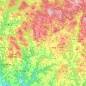
Name: Pabneukirchen topographic map, elevation, terrain.
Location: Pabneukirchen, Bezirk Perg, Upper Austria, 4363, Austria (48.27695 14.77993 48.37685 14.87941)
Average elevation: 610 m
Minimum elevation: 347 m
Maximum elevation: 875 m
Thank you for supporting this site ❤️
Make a donation
Make a donation
Other topographic maps
Click on a map to view its topography, its elevation and its terrain.