
Agrate topographic map
Click on the map to display elevation.
About this map
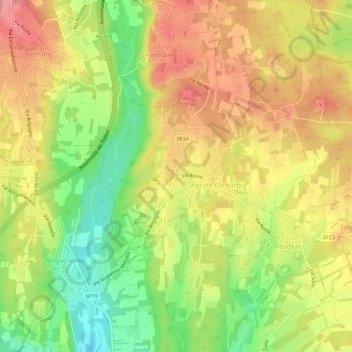
Name: Agrate topographic map, elevation, terrain.
Location: Agrate, Agrate Conturbia, Novara, Piedmont, Italy (45.65680 8.53293 45.69680 8.57293)
Average elevation: 324 m
Minimum elevation: 265 m
Maximum elevation: 373 m
Other topographic maps
Click on a map to view its topography, its elevation and its terrain.
Ameno
The municipal area is located on a large plateau overlooking the eastern shore of Lake Orta. The village is surrounded by coppiced woods and is a popular destination for summer holidays with numerous houses located along the road running between the mountain and the lake. The territory has an elevation ranging…
Average elevation: 468 m