
Thank you for supporting this site ❤️
Make a donation
Make a donation
Koh Kong topographic map
Click on the map to display elevation.
Thank you for supporting this site ❤️
Make a donation
Make a donation
About this map
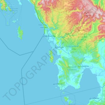
Name: Koh Kong topographic map, elevation, terrain.
Location: Koh Kong, Cambodia (10.65423 102.58498 12.11626 104.06456)
Average elevation: 142 m
Minimum elevation: -3 m
Maximum elevation: 1,299 m
Thank you for supporting this site ❤️
Make a donation
Make a donation
Other topographic maps
Click on a map to view its topography, its elevation and its terrain.