
Make a donation
Kigoma Region topographic map
Click on the map to display elevation.
Make a donation
Kigoma Region
Kigoma Region is on a plateau that slopes from the northeast at about 1,750 metres (5,740 ft) down to 800 metres (2,600 ft) at the shore of lake Tanganyika. The topography in the north and east is gently rolling hills that gradually become steeper as they get closer to the Albertine Rift margin. The most important river is the Malagarasi, with the Luiche and the Ruchugi being the two other major rivers draining the region.
Make a donation
About this map
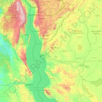
Name: Kigoma Region topographic map, elevation, terrain.
Location: Kigoma Region, Western Zone, Tanzania (-6.57282 29.59467 -2.83045 31.49326)
Average elevation: 1,215 m
Minimum elevation: 655 m
Maximum elevation: 3,421 m
Make a donation
Other topographic maps
Click on a map to view its topography, its elevation and its terrain.
Dodoma
Tanzania > Dodoma Region > Dodoma
The official capital since 1996, Dodoma was envisaged as the first non-monumental capital city as opposed to the monumentality and hierarchy of other planned capital cities such as Abuja, Brasília and Washington, D.C. It rejected geometrical forms such as grid iron and radial plans as inappropriate as the…
Average elevation: 1,145 m
Make a donation