
Thank you for supporting this site ❤️
Make a donation
Make a donation
Kamand topographic map
Click on the map to display elevation.
Thank you for supporting this site ❤️
Make a donation
Make a donation
About this map
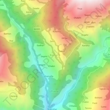
Name: Kamand topographic map, elevation, terrain.
Location: Kamand, Ani, Kullu District, Himachal Pradesh, 175038, India (31.45009 77.41288 31.49009 77.45288)
Average elevation: 1,903 m
Minimum elevation: 1,324 m
Maximum elevation: 2,616 m
Thank you for supporting this site ❤️
Make a donation
Make a donation
Other topographic maps
Click on a map to view its topography, its elevation and its terrain.