
Thank you for supporting this site ❤️
Make a donation
Make a donation
Serolsar Lake topographic map
Click on the map to display elevation.
Thank you for supporting this site ❤️
Make a donation
Make a donation
About this map
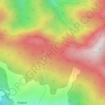
Name: Serolsar Lake topographic map, elevation, terrain.
Location: Serolsar Lake, Ani, Kullu District, Himachal Pradesh, India (31.53711 77.41610 31.53786 77.41728)
Average elevation: 2,979 m
Minimum elevation: 2,410 m
Maximum elevation: 3,444 m
Thank you for supporting this site ❤️
Make a donation
Make a donation
Other topographic maps
Click on a map to view its topography, its elevation and its terrain.