
Neapoli topographic map
Interactive map
Click on the map to display elevation.
About this map
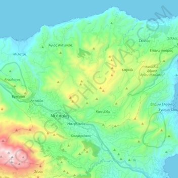
Name: Neapoli topographic map, elevation, terrain.
Average elevation: 380 m
Minimum elevation: -1 m
Maximum elevation: 1,477 m
Other topographic maps
Click on a map to view its topography, its elevation and its terrain.
Municipality of Orinon
Griechenland > Region Kreta > Regionalbezirk Lasithi > Δημοτική Ενότητα Μακρύ Γιαλού
Municipality of Orinon, Δημοτική Ενότητα Μακρύ Γιαλού, Provinz Ierapetra, Regionalbezirk Lasithi, Region Kreta, Griechenland
Average elevation: 528 m
Zourva
Griechenland > Region Kreta > Regionalbezirk Lasithi > Neapoli
Zourva, Gemeinde Latsida, Neapoli, Provinz Agios Nikolaos, Regionalbezirk Lasithi, Region Kreta, 721 00, Griechenland
Average elevation: 348 m
Νισπήτας
Griechenland > Region Kreta > Regionalbezirk Lasithi > Neapoli
Νισπήτας, Gemeinde Neapolis, Neapoli, Provinz Agios Nikolaos, Regionalbezirk Lasithi, Region Kreta, 721 00, Griechenland
Average elevation: 414 m
Δημοτική Ενότητα Αγίου Νικολάου
Griechenland > Region Kreta > Regionalbezirk Lasithi > Δημοτική Ενότητα Αγίου Νικολάου
Δημοτική Ενότητα Αγίου Νικολάου, Provinz Agios Nikolaos, Regionalbezirk Lasithi, Region Kreta, 72100, Griechenland
Average elevation: 531 m
Lastros
Griechenland > Region Kreta > Regionalbezirk Lasithi > Δημοτική Ενότητα Σητείας
Lastros, Δημοτική Ενότητα Σητείας, Provinz Sitia, Regionalbezirk Lasithi, Region Kreta, 720 57, Griechenland
Average elevation: 536 m