
Longfaye topographic map
Interactive map
Click on the map to display elevation.
About this map
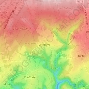
Name: Longfaye topographic map, elevation, terrain.
Location: Longfaye, Malmedy, Verviers, Luik, Wallonië, 4960, België (50.45140 6.06061 50.49140 6.10061)
Average elevation: 558 m
Minimum elevation: 413 m
Maximum elevation: 657 m
Other topographic maps
Click on a map to view its topography, its elevation and its terrain.
Chevofosse
België > Luik > Verviers > Malmedy
Chevofosse, Malmedy, Verviers, Luik, Wallonië, 4960, België
Average elevation: 369 m
Ligneuville
België > Luik > Verviers > Malmedy
Ligneuville, Malmedy, Verviers, Luik, Wallonië, 4960, België
Average elevation: 437 m
Burnenville
België > Luik > Verviers > Malmedy
Burnenville, Malmedy, Verviers, Luik, Wallonië, 4960, België
Average elevation: 413 m